16 Days
Annapurna Circuit Via Tilicho Lake Trek
The Annapurna Circuit via Tilicho Lake Trek is one of Nepal's most rewarding and diverse trekking adventures. It combines the classic Annapurna Circuit with a side trip to Tilicho Lake(4,919m) - one of the highest lakes in the world-offering dramatic landscapes, rich culture and high mountain passes.
18
Minimum Age
Annapurna Region
Location
$1400.00
Per Person

Overview
The Annapurna Circuit via Tilicho Lake is one of Nepal's most spectacular and diverse trekking journeys, combining the classic Annapurna Circuit with an adventurous side trip to one of the world's highest lakes. This trek circles the mighty Annapurna Massif, taking you through an incredible range of landscapes - from lush subtropical forests and terraced farmlands to alpine valleys and the dry, wind-swept desert of Mustang. The highlight is the visit to Tilicho Lake(4,919m), a breathtaking turquoise lake(if it's not frozen) set beneath towering peaks.
The journey continues across the challenging Thorong La Pass(5,416m), one of the highest trekking passes in the world, offering panoramic views of surrounding giants like Annapurna I-8,091m(the world's 10th highest peak, Manaslu-8,163m(the world's 8th highest peak) and Dhaulagiri-8,167m(the world's 7th highest peak). After the pass, the trail descends to the sacred Muktinath Temple, an important pilgrimage site for both Hindus and Buddhists.
Culturally, the trek is equally rich. You pass through traditional villages inhabited by Gurung, Thakali and Tibetan-influenced communities, where ancient monasteries, prayer flags and mani walls reflect deep spiritual traditions and mountain lifestyles. The trek typically takes 14 - 18 days, covering around 180 - 220 km, with daily walks of 10 - 15 km. It is considered a moderate to challenging trek, requiring good physical fitness and proper acclimatization due to high altitude.
Overall, this trek offers a complete Himalayan experience - adventure, culture, dramatic landscapes and high mountain challenges - making it one of the finest trekking routes in Nepal for those seeking both beauty and thrill.
Major Mountains & Elevations:
Annapurna I - 8,091m.
Dhaulagiri - 8,167m.
Manaslu - 8,163m.
Annapurna II - 7,937m.
Gangapurna - 7,455m.
Tilicho Peak - 7,134m.
Location & Geography:
Located in central Nepal within the Annapurna Conservation Area, the trek shows dramatic geographical variation:
Subtropical forests(lowlands).
River valleys and waterfalls.
Alpine meadows.
Glacial valleys.
High-altitude desert near Mustang.
Flora & Fauna:
Rhododendron forests(Nepal's national flower)
Pine, oak and bamboo forests.
Alpine grasses and shrubs.
Himalayan Thar.
Blue Sheep.
Snow Leopard(rare).
Danphe(Himalayan Monal - national bird of nepal).
People & Culture:
Gurung, Thakali and Tibetan-origin communities.
Strong influence of Buddhism and Bon religion.
Prayer flags, mani walls, monasteries.
Unique mountain lifestyle and hospitality.
Transportation:
Kathmandu - Jagat/Dharapani: Local bus or private jeep.
Muktinath/Jomsom - Pokhara: Jeep/bus or Flight.
Pokhara - Kathamandu: Tourist bus or flight.
Trek Duration & Distance:
Total Trek Days: 12 - 14 Days
Total Distance: 180 - 220 km.
Important Notes:
Proper acclimatization is essential(risk of AMS)
Weather can change rapidly at high altitude.
Physical fitness is required.
Final Insight:
This trek is a complete Himalayan experience - from lush green valleys to barren high - altitude deserts from cultural villages to extreme alpine crossings. The addition of Tilicho lake makes it even more adventurous and scenic than the standard Annapurna Circuit.
Trip Details
Trip Duration
16 days
Max Altitude
5416 m
Trip Difficulty
Moderate To Challenging
Accommodation
4 Star hotel in Kathmandu & Pokhara, Teahouses share Bedrooms During Your Trek
Best Season
Autumn(September-November) & Spring(February-May)
Meals
Breakfast, Lunch & Dinner incuded
Nearest Airport
Tribhuvan International Airport, Kathmandu
Local Transport
Bus, jeep, horses, donkeys
Annapurna Circuit Via Tilicho Lake Trek
Day 1
Arrival In Kathmandu(1,350m)
Our team will be waiting for you at Tribhuvan International Airport in Kathmandu to welcome you with garlands of marigold flowers. And you will drive to your hotel by private vehicle. Trek briefing by our team and last-minute gear shopping. Explore: Thamel's vibrant streets, traditional markets, visit some World UNESCO heritage sites Boudhanath/Swayambhunath if you arrived in time. Vibe: Buzzing cultural atmosphere, pre-trek excitement. Overnight at a 4 star hotel in Kathmandu.
Day 2
Drive From Kathmandu - Jagat(1,300m)
Drive Distance: 210 km. Drive Duration: 7-8 hrs. Elevation Loss: -50m. You leave Kathmandu early in the morning and drive along the Prithvi Highway , following the Trishuli River through terraced fields and rolling green hills. As the journey continues, you begin to see glimpses of snowcapped peaks in the distance. After reaching Besisahar , the road becomes rougher and winds through the Marsyangdi Valley , passing waterfalls, forests, and small Gurung and Magar villages . By late afternoon, you arrive in Jagat, a traditional stone-paved village where you spend your first night on the Annapurna Circuit.
Day 3
Trek From Jagat - Dharapani(1,960m)
Trek Distance: 14 km. Trek Duration: 6-7 hrs. Elevation Gain: +660m. You start your morning in the charming stone-paved lanes of Jagat , where the sound of the Marsyangdi River guides you along the trail. As you set off, you descend briefly through subtropical forests , then begin a steady climb past scattered farms and small hamlets. The path winds through terraced fields of maize, barley and rice giving you a glimpse into the traditional lifestyle of the Gurung and Magar communities . Soon, you reach Chamje , a village that clings to the steep valley side, marked by waterfalls cascading down rocky cliffs . Crossing a suspension bridge , you feel the thrill of walking above the roaring river before continuing into dense forests filled with bamboo, pine and the occasional troop of langur monkeys . The trail climbs steadily toward Tal Village(1,700m) , the first village of the Manang District . Here, the valley suddenly opens into a wide, flat plain where the river calms into a serene flow. Tal's cluster of stone houses , waterfalls tumbling from the cliffs and prayer flags fluttering in the breeze make it one of the most scenic stops of the day. You pause here for a well-deserved rest or lunch, soaking in the dramatic landscape . From Tal, the trail continues gently upward along the Marsyangdi River , weaving through pine forests and smaller settlements like Khotro and Karte . The sound of prayer wheels turning and the sight of mani walls remind you that you are entering the Buddhist cultural heart of the Himalayas . By late afternoon, you arrive in Dharapani(1,960m) , a larger village where trekkers from the Annapurna Circuit and the Manaslu Circuit often cross paths. Surrounded by pine forests and stone-built houses , Dharapani welcomes you with warm teahouses, hot meals and the satisfactions of completing your first full day on the trail.
Day 4
Trek From Dharapani - Chame(2,710m)
Trek Distance: 15 km. Trek Duration: 6-7 hrs. Elevation Gain: +710m. You wake up in Dharapani to the crisp mountain air and the sound of prayer flags fluttering . Leaving the village behind, you follow a winding trail through dense forests of pine, oak and maple . The river continues to rush alongside you, its turquoise water cutting through the valley as you gradually gain altitude. As you pass through Bagarchhap , you notice the change in culture-Tibetan-style stone houses , colorful prayer flags and small Buddhist stupas that signal your entry deeper into the Manang region . The air feels cooler and the landscape begins to shift from lush greenery to alpine terrain . Climbing steadily, you make your way to Timang(2,320m) , a village perched on a ridge that rewards you with breathtaking views of Manaslu-8,163m(the world 8th highest peak) and the surrounding peaks. Here, you pause for lunchManaslu-8,163m(the world 8th highest peak) and the surrounding peaks. Here, you pause for lunch break, soaking in the stunning Himalayan panorama. From Timang , the trail continues through forests of pine and fir, with the scent of resin filling the air. The path undulates, leading you through small settlements like Thanchok before gently descending into the wide valley where Chame(2,670m) lies. Chame, the headquarters of Manang District , is a lively hub with hot springs, bakeries and teahouses. Towering above the town, the sheer rock face known as Paungda Danda rises dramatically, creating one of the most iconic landscapes on the Annapurna Circuit . As you settle in for the night, you feel the trill of being surrounded by the mighty Himalayas-knowing the mountains will only grow closer and grander in the days ahead
Day 5
Trek From Chame - Lower Pisang(3,200m)
Trek Distance: 14 km. Trek Duration: 5-6 hrs. Elevation Gain: +530m. You leave Chame in the fresh morning air, following the Marsyangdi River deeper into the valley. The trail winds through tall pine forests and the crisp alpine scent accompanies you as the mountains rise ever higher around you. Soon, the massive curved rock wall of Paungda Danda comes into full view-a dramatic 1,500-merter cliff that looks like it has been sliced by a giant blade. This awe-inspiring natural wander becomes one of the highlights of the day. As you continue, the valley narrows and the trail hugs the cliffsides, crossing several suspension bridges above the roaring river . You pass small settlements where mani walls and prayer wheels remind you of the deep Buddhist roots of the Manang region . The higher you climb, the cooler and drier the air feels, signaling your gradual ascent into the rain shadow of the Annapurnas . After a steady but manageable trek, the valley opens wide, revealing spectacular views of Annapurna II(7,937m), Annapurna IV(7,525m) and Pisang Peak(6,091m) . The scenery shifts from dense forest to more rugged alpine landscapes with scattered juniper bushes and wide grazing pastures . By mid to late afternoon, you reach Lower Pisang(3,200m) , a traditional Tibetan-style village of flat-roofed stone houses surrounded by fields of barley and buckwheat . From here, you are greeted with sweeping views of the Annapurna range glowing golden in the evening sun. Lower Pisang offers a peaceful atmosphere, cozy teahouses and the first real feeling of being deep in the Himalayas.
Day 6
Trek From Lower Pisang - Manang Village(3,540m)
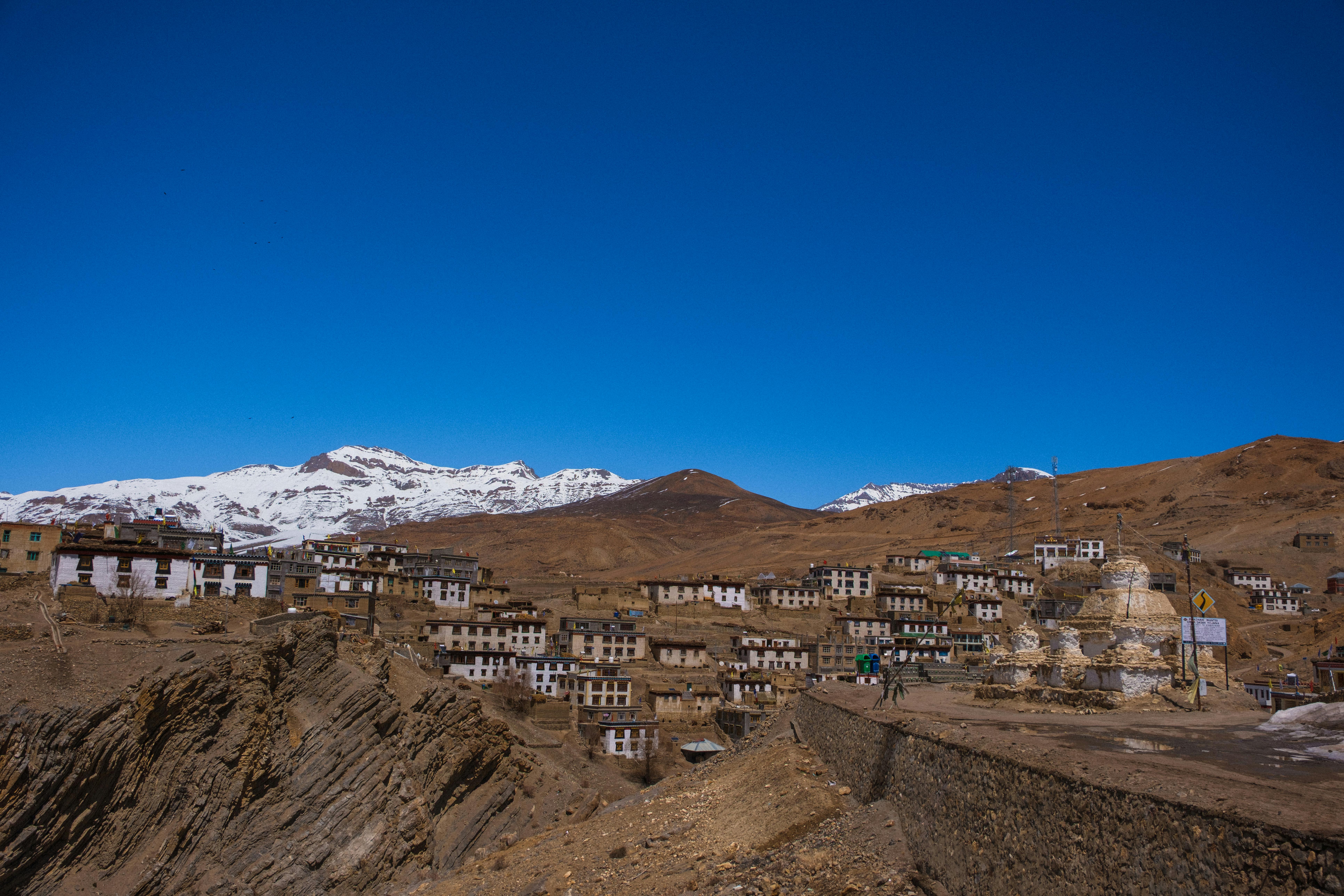
Trek Distance: 16 km(depends on routes) Trek Duration: 6-7 hrs. Elevation Gain: +340m. You wake up in Lower Pisang to a crisp alpine morning, the peaks of Annapurna II(7,937m), Annapurna III(7,555m), Annapurna IV(7,525m) and Pisang Peak(6,091m) glowing in the first light. Today's trek is one of the most scenic on the entire circuit and you have two route options: Lower Route(via Humde - shorter, easier): A gentler trail following the valley floor along the Marsyangdi River, passing small villages and the airstrip at Humde. Upper Route(via Ghyaru and Ngawal-longer, tougher, more rewarding): A steep climb up to ancient Tibetan-style villages perched high on the ridge, offering breathtaking panoramas of the Annapurna range and the entire valley below. Eventually, both trails meet again near Mungji and Braka , where you pass ancient Buddhist monasteries and long mani walls carved with prayers . The trail flattens as you make your final approach to Manang(3,540m) , a vibrant trading village and the cultural heart of the region . Manang is surrounded by towering peaks and sits in the dry, high-altitude valley of the Annapurnas . Here, you find cozy teahouses, bakeries and a lively atmosphere where trekkers and locals mingle. You feel a sense of accomplishment as you settle in, knowing you're now at the doorstep of the higher Himalayas. This day is a visual feast of mountain panoramas, Buddhist culture and traditional villages -making it one of the highlights of the Annapurna Circuit .
Day 7
Rest Day: Acclimatization
Today is your rest and acclimatization day in Manang , an essential pause to help your body adjust to the higher altitude before you ascend further toward Thorong La Pass . But don't worry-rest day doesn't mean boredom. In fact, Manang is one of the most fascinating villages on the circuit and you'll have plenty to see and do. You begin the morning with a relaxed walk through the stone-paved alleys of the village, lined with traditional Tibetan-style houses, chortens and prayer walls . The Annapurna range towers directly above, with Gangapurna Glacier and its turquoise glacial lake shining brightly nearby. For acclimatization, you can choose from several rewarding short hikes: Gangapurna Lake(3,800m): A gentle walk to the stunning turquoise lake at the foot of the Gangapurna Glacial, offering a close-up view of the icy giants. Milarepa's Cave(4,000m): A steep hike across the river to a sacred meditation cave linked to the Tibetan saint Milarepa, with sweeping views back over the valley. Ice Lake(4,600m) - Full-day option: A tougher climb, but if you're feeling energetic , the views of Annapurna II, III, IV, Gangapurna and Tilicho Peak from here are truly unforgettable. In the afternoon, you can relax at one of Manang's cozy bakeries with apple pie and coffee , visit the monasteries or explore the Himalayan Rescue Association's information center to learn about altitude sickness and mountain safety. As the sun sets, you find yourself surrounded by mountains glowing golden-Annapurna III(7,555m), Gangapurna(7,455m), Tilicho Peak(7,134m) and Chulu Peaks -and you feel deeply grateful for this pause in such a dramatic Himalayan amphitheater . This day gives you the chance to rest explore and prepare-both physically and mentally-for the higher trails and the crossing of Thorong La Pass ahead.
Day 8
Trek From Manang Village - Tilicho Base Camp(4,150m)
Trek Distance: 14 km. Trek Duration: 7 hours Elevation Gain: +610m. You start early in the morning, gradually climbing out of the valley with wide mountain views . The trail passes through Khangsar village , then becomes quieter and more rugged as you move toward Shri Kharka . Beyond Shri Kharka, the landscape turns dry, rocky and exposed . This final section is the most challenging, with narrow trails and landslide-prone slopes beneath t owering cliffs and views of Tilicho Peak.
Day 9
Hike To Tilicho Lake(4,919m) - Base Camp, Trek - Shri Kharka(4,060m)
Hiking Distance: 15 km(Round Trip) Hiking Duration: 5-6 hours(round trip) Trek Distance: 6 km Trek Duration: 3 hours elevation Gain/Loss: +7,69m at Tilicho Lake, -859m. at Shri Kharka From Tilicho Base Camp , you start very early in the morning and hike uphill to Tilicho Lake(4,919m) . The trail is steep, cold and at high altitude, but the reward is the stunning view of one the world's highest lakes surrounding by dramatic Himalayan peaks . After spending some time at the lake, you return along the same route back to base camp for breakfast. Then, instead of staying overnight, you continue trekking down toward Shri Kharka . This section involves careful walking along narrow, rocky and landslide-prone trails . Overall, it is a long and physically demanding day, combining a high-altitude hike with a descent, but it is also one of the most rewarding parts of the Annapurna Circuit with tilicho Lake .
Day 10
Trek From Shri Kharka - Yak Kharka(4,050m)
Trek Distance: 10 km. Trek Duration: 5 - 6 hours Elevation Loss: - 10m You begin by descending gradually from Shri Kharka, leaving the Tilicho route behind. The trail passes through dry alpine terrain , with wide-open views and fewer trees. After some walking, you join the main Annapurna Circuit trail near Yak Kharka trail junction , then continue toward Yak Kharka. The path is mostly gently with some ups and downs, making it less strenuous than previous days. Along the way, you may see yaks, their pastures and blue sheep, small teahouses and expansive mountain scenery.
Day 11
Trek From Yak Kharka - Thorong Phedi(4,450m)
Trek Distance: 10 km. Trek Duration: 4 - 5 hours. Elevation Gain: +400m You set out from Yak Kharka after breakfast, feeling the crisp chill of the thin mountain air. The trail begins with a gradual climb along the valley, following the Jarsang Khola(river) . The landscape is stark but beautiful-brown hillsides dotted with juniper shrubs, grazing yaks and the occasional cluster of stone-built teahouses . Above you, the snowy peaks of Gundang(5,312m), Syagang(6,026m) and Thorong Peak(6,144m) glisten in the sunlight, reminding you of the heights still to come. The path is steady but demands patience. You cross two suspension bridges , then climb a narrow trail cut into the hillside where the terrain becomes more rugged. The valley narrows and you carefully watch you footing as loose stones crunch beneath your boots. With every step, the sense of anticipation grows-you are now very close to Thorong La, the highest point of your trek . After 3-4 hours of walking at a slow, steady pace, you reach Thorong Phedi(4,450m) , a small settlement tucked at the foot of the massive pass. The word "Phedi" means "base" and this is exactly what the village feels like-a final resting point before tomorrow's big climb. Most trekkers stop here to rest, but if you're feeling strong and well-acclimatized, you can push another hour higher to High Camp(4,880m) , which makes the next day's pass crossing a bit shorter. Wherever you stay, you spend the afternoon relaxing, hydrating and preparing mentally for the challenge of crossing Thorong La Pass-one of the highest trekking passes in the world .
Day 12
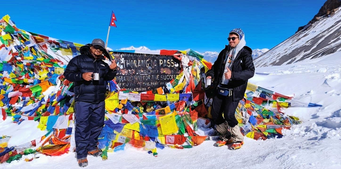
Trek From Thorong Phedi - Thorong La Pass(5,416m) - Muktinath(3,800m)
Trek Distance: 15 km. Trek Duration: 8 - 10 hours. Elevation Gain/Loss: +966m. at Thorong La Pass, -1,616m at Muktinath Today is the highlight of your Annapurna Circuit Trek-the legendary crossing of Thorong La Pass , the highest point of the trail. You wake up in the early pre-dawn chill, bundled in layers, ready to tackle the steep ascent. The world is quiet, with only the crunch of your boots on the snow/ice-dusted trail and the occasional flicker of headlamps guiding you upward. From High Camp(4,860m) or Thorong Phedi(4,450m) , the trail climbs steadily but sharply, zigzagging across the barren mountainside. The air is thin, and each breath reminds you of the high altitude. Yet the anticipation and exhilaration keep you moving. As the sun rises, the snow-covered peaks of Annapurna, Dhaulagiri(8,167m), the world 7th highest peak and Nilgiri light up in gold and pink-an unforgettable spectacle. After several hours of steady trekking, you finally reach Thorong La Pass(5,416m) . Standing here, you are on top of the world. Prayer flags flutter in the icy wind , and you take a moment to soak in the 360-degree panorama of the Himalayas stretching endlessly in every direction. This is the moment of triumph, achievement and awe-a memory that will stay with you forever . This day combines physical challenge, spiritual experience and unparalleled Himalayan scenery , making the pinnacle of your Annapurna Circuit adventure . Once you've taken photos, rested and celebrated, the journey continues downhill to Muktinath(3,800m) . The descent is long but scenic, winding past barren valleys, small glaciers and isolated settlements . The trail gradually opens into the sacred village of Muktinath , home to one of Nepal's most revered Hindu and Buddhist Pilgrimage sites, where the 108-water spouts of the temple offer a spiritual welcome. By late afternoon, you arrive in Muktinath, tired but fulfilled and settle into a cozy teahouse. Here, you can enjoy a well-earned meal and reflect on the extraordinary achievement of crossing one of the highest trekking passes in the world.
Day 13
Drive From Muktinath - Pokhara(822m)/fly from Jomsom - Pokhara
Drive Distance: 180 km. Drive Duration: 8 - 9 hours. Elevation Loss: -2,978m. The drive from Muktinath to Pokhara is a long and scenic journey that takes you from the dry, high-altitude Mustang region down to the green hills of central Nepal. You begin by descending through a rough and dusty road toward Jomsom , passing through barren landscapes with strong winds and views of Mountains like Dhaulagiri-8,167m (the world 7th highest peak) and Nilgiri. The route then follows the Kali Gandaki valley(The world deepest gorge) , going through traditional villages such as Marpha , known for its apple orchards and Thakali culture . As you continue, the landscape gradually changes- dry terrain turns into forests, rivers, waterfalls and terraced fields . After reaching Beni, the road becomes smoother and the drive continues comfortably toward Pokhara. Overall, it is a full-day drive with mixed road conditions but it offers a beautiful transition from Himalayan desert to lush green countryside.
Day 14
Drive/Fly From Pokhara - Kathmandu(1,350m)
Drive Distance: 200 km Drive Duration: 7 - 8 hours/Flight Duration: 20-25 minutes. Elevation Gain: +528m. After an unforgettable trek, relax on a scenic drive from Pokhara to Kathmandu along the winding Prithvi Highway. The journey takes you through lush valleys, terraced farmlands and riverside villages, with glimpses of the Himalayan foothills along the way. Passing charming town and local markets, this drive offers a perfect opportunity to soak in Nepal's natural beauty before arriving in the bustling capital. Overnight at a 4 star hotel in Kathmandu Farewell dinner with traditional cultural dances at 7pm in Kathmandu.
Day 15
Final Departure, Fly Back To Home Country
Transfer to the Airport, included. Our team will drop you at the airport after farewell with an unforgettable experience of Annapurna Circuit Adventure. Thank you very much for being with us.
Day 1
Arrival In Kathmandu(1,350m)
Our team will be waiting for you at Tribhuvan International Airport in Kathmandu to welcome you with garlands of marigold flowers. And you will drive to your hotel by private vehicle. Trek briefing by our team and last-minute gear shopping. Explore: Thamel's vibrant streets, traditional markets, visit some World UNESCO heritage sites Boudhanath/Swayambhunath if you arrived in time. Vibe: Buzzing cultural atmosphere, pre-trek excitement. Overnight at a 4 star hotel in Kathmandu.
Day 2
Drive From Kathmandu - Jagat(1,300m)
Drive Distance: 210 km. Drive Duration: 7-8 hrs. Elevation Loss: -50m. You leave Kathmandu early in the morning and drive along the Prithvi Highway , following the Trishuli River through terraced fields and rolling green hills. As the journey continues, you begin to see glimpses of snowcapped peaks in the distance. After reaching Besisahar , the road becomes rougher and winds through the Marsyangdi Valley , passing waterfalls, forests, and small Gurung and Magar villages . By late afternoon, you arrive in Jagat, a traditional stone-paved village where you spend your first night on the Annapurna Circuit.
Day 3
Trek From Jagat - Dharapani(1,960m)
Trek Distance: 14 km. Trek Duration: 6-7 hrs. Elevation Gain: +660m. You start your morning in the charming stone-paved lanes of Jagat , where the sound of the Marsyangdi River guides you along the trail. As you set off, you descend briefly through subtropical forests , then begin a steady climb past scattered farms and small hamlets. The path winds through terraced fields of maize, barley and rice giving you a glimpse into the traditional lifestyle of the Gurung and Magar communities . Soon, you reach Chamje , a village that clings to the steep valley side, marked by waterfalls cascading down rocky cliffs . Crossing a suspension bridge , you feel the thrill of walking above the roaring river before continuing into dense forests filled with bamboo, pine and the occasional troop of langur monkeys . The trail climbs steadily toward Tal Village(1,700m) , the first village of the Manang District . Here, the valley suddenly opens into a wide, flat plain where the river calms into a serene flow. Tal's cluster of stone houses , waterfalls tumbling from the cliffs and prayer flags fluttering in the breeze make it one of the most scenic stops of the day. You pause here for a well-deserved rest or lunch, soaking in the dramatic landscape . From Tal, the trail continues gently upward along the Marsyangdi River , weaving through pine forests and smaller settlements like Khotro and Karte . The sound of prayer wheels turning and the sight of mani walls remind you that you are entering the Buddhist cultural heart of the Himalayas . By late afternoon, you arrive in Dharapani(1,960m) , a larger village where trekkers from the Annapurna Circuit and the Manaslu Circuit often cross paths. Surrounded by pine forests and stone-built houses , Dharapani welcomes you with warm teahouses, hot meals and the satisfactions of completing your first full day on the trail.
Day 4
Trek From Dharapani - Chame(2,710m)
Trek Distance: 15 km. Trek Duration: 6-7 hrs. Elevation Gain: +710m. You wake up in Dharapani to the crisp mountain air and the sound of prayer flags fluttering . Leaving the village behind, you follow a winding trail through dense forests of pine, oak and maple . The river continues to rush alongside you, its turquoise water cutting through the valley as you gradually gain altitude. As you pass through Bagarchhap , you notice the change in culture-Tibetan-style stone houses , colorful prayer flags and small Buddhist stupas that signal your entry deeper into the Manang region . The air feels cooler and the landscape begins to shift from lush greenery to alpine terrain . Climbing steadily, you make your way to Timang(2,320m) , a village perched on a ridge that rewards you with breathtaking views of Manaslu-8,163m(the world 8th highest peak) and the surrounding peaks. Here, you pause for lunchManaslu-8,163m(the world 8th highest peak) and the surrounding peaks. Here, you pause for lunch break, soaking in the stunning Himalayan panorama. From Timang , the trail continues through forests of pine and fir, with the scent of resin filling the air. The path undulates, leading you through small settlements like Thanchok before gently descending into the wide valley where Chame(2,670m) lies. Chame, the headquarters of Manang District , is a lively hub with hot springs, bakeries and teahouses. Towering above the town, the sheer rock face known as Paungda Danda rises dramatically, creating one of the most iconic landscapes on the Annapurna Circuit . As you settle in for the night, you feel the trill of being surrounded by the mighty Himalayas-knowing the mountains will only grow closer and grander in the days ahead
Day 5
Trek From Chame - Lower Pisang(3,200m)
Trek Distance: 14 km. Trek Duration: 5-6 hrs. Elevation Gain: +530m. You leave Chame in the fresh morning air, following the Marsyangdi River deeper into the valley. The trail winds through tall pine forests and the crisp alpine scent accompanies you as the mountains rise ever higher around you. Soon, the massive curved rock wall of Paungda Danda comes into full view-a dramatic 1,500-merter cliff that looks like it has been sliced by a giant blade. This awe-inspiring natural wander becomes one of the highlights of the day. As you continue, the valley narrows and the trail hugs the cliffsides, crossing several suspension bridges above the roaring river . You pass small settlements where mani walls and prayer wheels remind you of the deep Buddhist roots of the Manang region . The higher you climb, the cooler and drier the air feels, signaling your gradual ascent into the rain shadow of the Annapurnas . After a steady but manageable trek, the valley opens wide, revealing spectacular views of Annapurna II(7,937m), Annapurna IV(7,525m) and Pisang Peak(6,091m) . The scenery shifts from dense forest to more rugged alpine landscapes with scattered juniper bushes and wide grazing pastures . By mid to late afternoon, you reach Lower Pisang(3,200m) , a traditional Tibetan-style village of flat-roofed stone houses surrounded by fields of barley and buckwheat . From here, you are greeted with sweeping views of the Annapurna range glowing golden in the evening sun. Lower Pisang offers a peaceful atmosphere, cozy teahouses and the first real feeling of being deep in the Himalayas.
Day 6
Trek From Lower Pisang - Manang Village(3,540m)
Trek Distance: 16 km(depends on routes) Trek Duration: 6-7 hrs. Elevation Gain: +340m. You wake up in Lower Pisang to a crisp alpine morning, the peaks of Annapurna II(7,937m), Annapurna III(7,555m), Annapurna IV(7,525m) and Pisang Peak(6,091m) glowing in the first light. Today's trek is one of the most scenic on the entire circuit and you have two route options: Lower Route(via Humde - shorter, easier): A gentler trail following the valley floor along the Marsyangdi River, passing small villages and the airstrip at Humde. Upper Route(via Ghyaru and Ngawal-longer, tougher, more rewarding): A steep climb up to ancient Tibetan-style villages perched high on the ridge, offering breathtaking panoramas of the Annapurna range and the entire valley below. Eventually, both trails meet again near Mungji and Braka , where you pass ancient Buddhist monasteries and long mani walls carved with prayers . The trail flattens as you make your final approach to Manang(3,540m) , a vibrant trading village and the cultural heart of the region . Manang is surrounded by towering peaks and sits in the dry, high-altitude valley of the Annapurnas . Here, you find cozy teahouses, bakeries and a lively atmosphere where trekkers and locals mingle. You feel a sense of accomplishment as you settle in, knowing you're now at the doorstep of the higher Himalayas. This day is a visual feast of mountain panoramas, Buddhist culture and traditional villages -making it one of the highlights of the Annapurna Circuit .
Day 7
Rest Day: Acclimatization
Today is your rest and acclimatization day in Manang , an essential pause to help your body adjust to the higher altitude before you ascend further toward Thorong La Pass . But don't worry-rest day doesn't mean boredom. In fact, Manang is one of the most fascinating villages on the circuit and you'll have plenty to see and do. You begin the morning with a relaxed walk through the stone-paved alleys of the village, lined with traditional Tibetan-style houses, chortens and prayer walls . The Annapurna range towers directly above, with Gangapurna Glacier and its turquoise glacial lake shining brightly nearby. For acclimatization, you can choose from several rewarding short hikes: Gangapurna Lake(3,800m): A gentle walk to the stunning turquoise lake at the foot of the Gangapurna Glacial, offering a close-up view of the icy giants. Milarepa's Cave(4,000m): A steep hike across the river to a sacred meditation cave linked to the Tibetan saint Milarepa, with sweeping views back over the valley. Ice Lake(4,600m) - Full-day option: A tougher climb, but if you're feeling energetic , the views of Annapurna II, III, IV, Gangapurna and Tilicho Peak from here are truly unforgettable. In the afternoon, you can relax at one of Manang's cozy bakeries with apple pie and coffee , visit the monasteries or explore the Himalayan Rescue Association's information center to learn about altitude sickness and mountain safety. As the sun sets, you find yourself surrounded by mountains glowing golden-Annapurna III(7,555m), Gangapurna(7,455m), Tilicho Peak(7,134m) and Chulu Peaks -and you feel deeply grateful for this pause in such a dramatic Himalayan amphitheater . This day gives you the chance to rest explore and prepare-both physically and mentally-for the higher trails and the crossing of Thorong La Pass ahead.
Day 8
Trek From Manang Village - Tilicho Base Camp(4,150m)
Trek Distance: 14 km. Trek Duration: 7 hours Elevation Gain: +610m. You start early in the morning, gradually climbing out of the valley with wide mountain views . The trail passes through Khangsar village , then becomes quieter and more rugged as you move toward Shri Kharka . Beyond Shri Kharka, the landscape turns dry, rocky and exposed . This final section is the most challenging, with narrow trails and landslide-prone slopes beneath t owering cliffs and views of Tilicho Peak.
Day 9
Hike To Tilicho Lake(4,919m) - Base Camp, Trek - Shri Kharka(4,060m)
Hiking Distance: 15 km(Round Trip) Hiking Duration: 5-6 hours(round trip) Trek Distance: 6 km Trek Duration: 3 hours elevation Gain/Loss: +7,69m at Tilicho Lake, -859m. at Shri Kharka From Tilicho Base Camp , you start very early in the morning and hike uphill to Tilicho Lake(4,919m) . The trail is steep, cold and at high altitude, but the reward is the stunning view of one the world's highest lakes surrounding by dramatic Himalayan peaks . After spending some time at the lake, you return along the same route back to base camp for breakfast. Then, instead of staying overnight, you continue trekking down toward Shri Kharka . This section involves careful walking along narrow, rocky and landslide-prone trails . Overall, it is a long and physically demanding day, combining a high-altitude hike with a descent, but it is also one of the most rewarding parts of the Annapurna Circuit with tilicho Lake .
Day 10
Trek From Shri Kharka - Yak Kharka(4,050m)
Trek Distance: 10 km. Trek Duration: 5 - 6 hours Elevation Loss: - 10m You begin by descending gradually from Shri Kharka, leaving the Tilicho route behind. The trail passes through dry alpine terrain , with wide-open views and fewer trees. After some walking, you join the main Annapurna Circuit trail near Yak Kharka trail junction , then continue toward Yak Kharka. The path is mostly gently with some ups and downs, making it less strenuous than previous days. Along the way, you may see yaks, their pastures and blue sheep, small teahouses and expansive mountain scenery.
Day 11
Trek From Yak Kharka - Thorong Phedi(4,450m)
Trek Distance: 10 km. Trek Duration: 4 - 5 hours. Elevation Gain: +400m You set out from Yak Kharka after breakfast, feeling the crisp chill of the thin mountain air. The trail begins with a gradual climb along the valley, following the Jarsang Khola(river) . The landscape is stark but beautiful-brown hillsides dotted with juniper shrubs, grazing yaks and the occasional cluster of stone-built teahouses . Above you, the snowy peaks of Gundang(5,312m), Syagang(6,026m) and Thorong Peak(6,144m) glisten in the sunlight, reminding you of the heights still to come. The path is steady but demands patience. You cross two suspension bridges , then climb a narrow trail cut into the hillside where the terrain becomes more rugged. The valley narrows and you carefully watch you footing as loose stones crunch beneath your boots. With every step, the sense of anticipation grows-you are now very close to Thorong La, the highest point of your trek . After 3-4 hours of walking at a slow, steady pace, you reach Thorong Phedi(4,450m) , a small settlement tucked at the foot of the massive pass. The word "Phedi" means "base" and this is exactly what the village feels like-a final resting point before tomorrow's big climb. Most trekkers stop here to rest, but if you're feeling strong and well-acclimatized, you can push another hour higher to High Camp(4,880m) , which makes the next day's pass crossing a bit shorter. Wherever you stay, you spend the afternoon relaxing, hydrating and preparing mentally for the challenge of crossing Thorong La Pass-one of the highest trekking passes in the world .
Day 12
Trek From Thorong Phedi - Thorong La Pass(5,416m) - Muktinath(3,800m)
Trek Distance: 15 km. Trek Duration: 8 - 10 hours. Elevation Gain/Loss: +966m. at Thorong La Pass, -1,616m at Muktinath Today is the highlight of your Annapurna Circuit Trek-the legendary crossing of Thorong La Pass , the highest point of the trail. You wake up in the early pre-dawn chill, bundled in layers, ready to tackle the steep ascent. The world is quiet, with only the crunch of your boots on the snow/ice-dusted trail and the occasional flicker of headlamps guiding you upward. From High Camp(4,860m) or Thorong Phedi(4,450m) , the trail climbs steadily but sharply, zigzagging across the barren mountainside. The air is thin, and each breath reminds you of the high altitude. Yet the anticipation and exhilaration keep you moving. As the sun rises, the snow-covered peaks of Annapurna, Dhaulagiri(8,167m), the world 7th highest peak and Nilgiri light up in gold and pink-an unforgettable spectacle. After several hours of steady trekking, you finally reach Thorong La Pass(5,416m) . Standing here, you are on top of the world. Prayer flags flutter in the icy wind , and you take a moment to soak in the 360-degree panorama of the Himalayas stretching endlessly in every direction. This is the moment of triumph, achievement and awe-a memory that will stay with you forever . This day combines physical challenge, spiritual experience and unparalleled Himalayan scenery , making the pinnacle of your Annapurna Circuit adventure . Once you've taken photos, rested and celebrated, the journey continues downhill to Muktinath(3,800m) . The descent is long but scenic, winding past barren valleys, small glaciers and isolated settlements . The trail gradually opens into the sacred village of Muktinath , home to one of Nepal's most revered Hindu and Buddhist Pilgrimage sites, where the 108-water spouts of the temple offer a spiritual welcome. By late afternoon, you arrive in Muktinath, tired but fulfilled and settle into a cozy teahouse. Here, you can enjoy a well-earned meal and reflect on the extraordinary achievement of crossing one of the highest trekking passes in the world.
Day 13
Drive From Muktinath - Pokhara(822m)/fly from Jomsom - Pokhara
Drive Distance: 180 km. Drive Duration: 8 - 9 hours. Elevation Loss: -2,978m. The drive from Muktinath to Pokhara is a long and scenic journey that takes you from the dry, high-altitude Mustang region down to the green hills of central Nepal. You begin by descending through a rough and dusty road toward Jomsom , passing through barren landscapes with strong winds and views of Mountains like Dhaulagiri-8,167m (the world 7th highest peak) and Nilgiri. The route then follows the Kali Gandaki valley(The world deepest gorge) , going through traditional villages such as Marpha , known for its apple orchards and Thakali culture . As you continue, the landscape gradually changes- dry terrain turns into forests, rivers, waterfalls and terraced fields . After reaching Beni, the road becomes smoother and the drive continues comfortably toward Pokhara. Overall, it is a full-day drive with mixed road conditions but it offers a beautiful transition from Himalayan desert to lush green countryside.
Day 14
Drive/Fly From Pokhara - Kathmandu(1,350m)
Drive Distance: 200 km Drive Duration: 7 - 8 hours/Flight Duration: 20-25 minutes. Elevation Gain: +528m. After an unforgettable trek, relax on a scenic drive from Pokhara to Kathmandu along the winding Prithvi Highway. The journey takes you through lush valleys, terraced farmlands and riverside villages, with glimpses of the Himalayan foothills along the way. Passing charming town and local markets, this drive offers a perfect opportunity to soak in Nepal's natural beauty before arriving in the bustling capital. Overnight at a 4 star hotel in Kathmandu Farewell dinner with traditional cultural dances at 7pm in Kathmandu.
Day 15
Final Departure, Fly Back To Home Country
Transfer to the Airport, included. Our team will drop you at the airport after farewell with an unforgettable experience of Annapurna Circuit Adventure. Thank you very much for being with us.


Uncover Hidden Wilderness Together!
Often celebrated as a harmonious union of physical activity and natural exploration become an enriching journey for both body and mind.
