Menu
20 Days
Kanchenjunga Kanchenjunga Circuit Trek
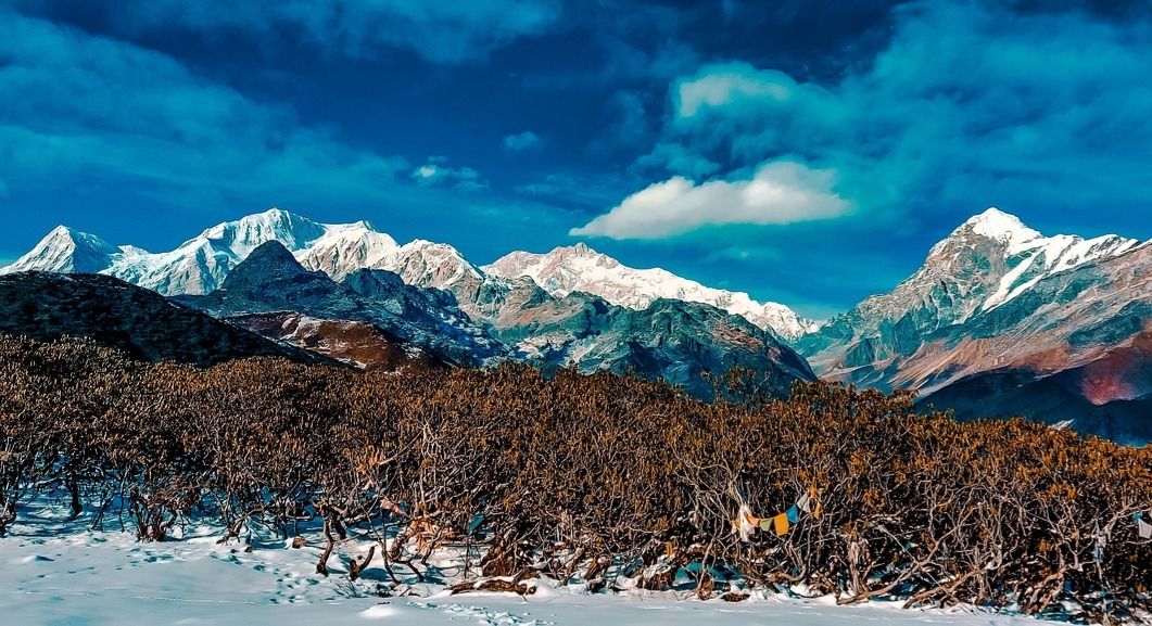
Embark on one of Nepal's most spectacular and remote journeys-the Kanchenjunga Circuit Trek, a breathtaking adventure around the world's third-highest mountain(8,586m). This epic 18-day trek takes you deep into the pristine Himalayas, crossing through rhododendron forests, remote Rai and Limbu villages and high alpine valleys before reaching both the North Base Camp(Pangpema-5,143m) and the south Base Camp(Oktang-4,610m). Perfect for true adventures, the Kanchenjunga Circuit is not just a trek - it's a journey into one of the most untouched corners of the Himalayas, where nature, culture and towering peaks create memories for a lifetime.
18
Minimum Age
Kanchenjunga
Location
$2450.00
Per Person
Overview
The Kanchenjunga Circuit Trek is one of Nepal's most adventurous and rewarding journeys, taking you around Mt. Kanchenjunga(8,586m), the world's third-highest peak. Unlike the busy Everest and Annapurna trails, Kanchenjunga remains remote, wild and culturally rich, offering trekkers the perfect blend of Himalayan wilderness, ethnic cultures and majestic mountains.
This 20-day trek allows you to explore both Kanchenjunga North Base Camp(Pangpema-5,143m) and South Base Camp(Oktang-4,730m), giving two dramatic perspectives of this giant mountain. The circuit passes through lush subtropical valleys, alpine forestss, high yak pastures and glacial moraine landscapes, with daily encounters of local Rai, Limbu, Sherpa and Tibetan cultures.
Transportation:
45 minutes flight from Kathmandu to Bhardrapur.
8-9 hours jeep drive from Bhadrapur to Taplejung.
Trek starts: Taplejung/Mitlung.
Trek ends: Yamphudin/Khebang.
Drive: From Yamphudin to Birtamot(Jeep: 7-8 hours)
Flight: From Bhadrapur to Kathmandu(45 mins)
Total Trek Distance: 210 km.
Daily Average Trek Distance: 13 km (5-7 hrs trekking)
Major Peaks Visible:
Kanchejunga Main - 8,586m(3rd highest mountain in the world).
Kanchenjunga South - 8,476m.
Kanchenjunga Central - 8,482m.
Kanchenjunga West(Yalung Kang) - 8,505m.
Mt. Jannu(Kumbhakarna) - 7,710m.
Kabru Range - 7,412m.
Rathong - 6,679m.
Tent Peak, Nepal Peak, Wedge Peak
Flora & Fauna:
The trek passes through the Kanchenjunga Conservation Area Project(KCAP), home to:
Flora: Subtropical forests, rhododendrons, magnolias, bamboo groves, junipers alpine meadows.
Fauna: Red Panda, Himalayan Black Bear, Snow Leopard, Blue Sheep, Musk Deer, Himalayan Monal(Danphe-Nepal's national bird).
People & Cultures:
Rai & Limbu: Indigenous people of lower valleys, known for rich traditions and hospitality.
Sherpa & Tibetan communities: In higher regions, with prayer flags, chortens and ancient monasteries.
Strong Buddhist influence: Mani walls, prayer wheels and Gompas.
Festivals: Lhosar, Chasok Tangnam and Buddhist rituals.
Why Choose This Trek?
Unlike Everest or Annapurna, the Kanchenjunga Circuit Trek offers pure wilderness with fewer trekkers, two incredible Base Camps, rare wildlife and deep cultural immersion. It's the ultimate Himalayan adventure for those seeking authentic trekking experiences far from the crowds.
Trip Details
Trip Duration
20 days
Max Altitude
5143 m
Trip Difficulty
Strenuous/Remote wilderness
Accommodation
4 star Hotel in Kathmandu and Teahouses during your trek
Best Season
Spring: March-May, Autumn: September - November
Meals
Included
Nearest Airport
Bhadrapur
Local Transport
Flight, Road Transportation; Bus, Car,Jeep, Donkey, Horses, Yak
Kanchenjunga Kanchenjunga Circuit Trek
Day 1
Arrival In Kathmandu-1,350m
A member of our team of GMA will be waiting for you at Kathmandu International Airport to have a warm hospitality with the garlands of marigold flowers and drive to your hotel by a private vehicle. Meet your trek guide and will have a briefing about your trek preparation, shopping gears. Explore: Thamel's vibrant streets, traditional markets, visit Boudhanath/Swayambhunath if you arrived in time. Vibe: Buzzing cultural atmosphere, pre-trek excitement. Overnight at a 4 star hotel at Thamel in Kathmandu. Welcome Dinner with traditional cultural dances at 7pm.
Day 2
Fly From Kathmandu To Bhadrapur(91m), Drive To Taplejung(1,820m)
Flight Duration: 45 - 50 minutes Drive Distance: 240 km. Drive Duration: 7- 8 hours. Elevation Gain: + 470m. Your adventure begins with a scenic 45-minute flight form Kathmandu to Bhadrapur , located in Nepal's subtropical eastern Terai. On a clear morning, the flight rewards you with breathtaking aerial views of the Himalayan range , including Everest, Lhotse, Makalu and Kanchenjunga. Landing at Bhadrapur, you'll feel the warm climate and lush lowlands of Nepal's southeastern plains. From here, a jeep ride takes you gradually uphill through the fertile tea-growing hills of Ilam, famous for its rolling green carpets of tea gardens, cardamom farms, and terraced fields . As the road winds higher into the Himalayan foothills , you pass through charming hill towns , subtropical forests and river valleys before reaching Taplejung - the gateway to the Kanchenjunga region . This long but scenic day connects the bustling capital with the remote eastern hills, setting the tone for your Kanchenjunga Circuit adventure .
Day 3
Drive From Taplejung To Sekathum(1,660m)
Drive Distance: 65 km. Drive Duration: 3 - 4 hours. Elevation Loss: -160m. The drive winds through lush green hills, terraced fields and small rivers with local villages, tea gardens and forests along the way. You'll notice Rai and Limbu communities, with wooden houses, small shrines and prayer flags marking villages. Road Conditions: Partially paved, with some gravel stretches. Scenic views of surrounding hills and distant peaks of the Kanchenjunga range. Observation of local farming practices and traditional village life. River crossing and small suspension bridges adding an adventurous feel. By the time you reach Sekathum, you're well-acclimatized and ready to begin the trek further into the Kanchenjunga circuit, heading toward higher alpine regions.
Day 4
Trek From Sekathum To Amjilosa(2,510m)
Trek Distance: 11 km. Trek Duration: 5-6 hours. Elevation Gain: +850m. You start your journey along the Ghunsa Khola(river) , its clear waters roaring beside you as you follow narrow trails carved into the cliffs. The path is undulating and rugged, with short ascents and descents through dense rhododendron and bamboo forests-a paradise for birdlife and occasional glimpses of monkeys. As you move ahead, you'll pass by tiny hamlets and isolated shelters, where locals live a traditional lifestyle , often seen carrying baskets of supplies along the same trail you're trekking. Crossing suspension bridges adds an adventurous touch, with the river rushing far below. The trail gradually gets steeper, demanding steady steps, but each climb rewards you with refreshing views of green hills, cascading waterfalls and distant snow peaks . The air becomes cooler and fresher as you gain elevation. After about 5-6 hours of trekking, you finally arrive at Amjilosa-a small but charming settlement perched on a ridge surrounded by forest. The village is home to Tibetan and Sherpa families and you'll find basic teahouses offering warmth, local meals and smiles.
Day 5
Trek From Amjilosa To Gyabla(Kyapra)-2,730m.
Trek Distance: 9 km. Trek Duration: 4-5 hours. Elevation Gain: +220m After waking up in the peaceful village of Amjilosa , you set off along a trail that winds deeper into the Ghunsa Valley . Today's journey is gentler compared to yesterday's steep ascents but still filled with adventure. You begin by following the river, where the sound of rushing water accompanies you like a constant friend. The trail passes through dense forests of oak, pine, bamboo and rhododendron, alive with birdsong . If you're lucky, you might glimpse a red panda or a troop of langurs moving quietly through the trees. The path takes you across small streams and over wooden bridges , with waterfalls tumbling down moss-covered cliffs . As you gain gradual elevation, the landscape starts to open up, revealing alpine meadows dotted with prayer flags and grazing yaks . After about 4 - 5 hours of trekking, you reach the hidden village of Gyabla , also known as Kyapra. This small hamlet is nestled in a serene valley, surrounded by thick forest and dramatic ridges . The settlement is home to Tibetan refugees and Sherpa families , giving you the chance to experience warm hospitality and authentic local culture . Life here is slow and traditional-villagers often tend their animals or spin prayer wheels outside small stone houses. Spending the night here feels like stepping back in time, as you're welcomed with smiles and hearty local meals .
Day 6
Trek From Gyabla To Ghunsa(3,595m).
Trek Distance: 14 km. Trek Duration: 6-7 hours. Elevation Gain: +865m. You wake up to the crisp mountain air in Gyabla , surrounded by forested ridges. After breakfast, you set off on the trail, gradually leaving behind the dense oak and rhododendron forests. The path follows the Ghunsa Khola upstream and the sound of rushing water guides your steps. As you climb higher, the landscape changes dramatically. The thick forests slowly give way to open alpine pastures and wider valleys. The trail is dotted with waterfalls cascading down rocky cliffs, and you'll often cross wooden bridges suspended above clear streams. You pass through Phale(3,140m) , a Tibetan refugee village established decades ago. Here you'll see stone houses, prayer walls and fluttering prayer flags -a first real taste of Tibetan Buddhist culture on this trek. Stopping here for tea feels like a journey into another world, where traditions are preserved in the shadow of the great Himalayas. From Phale, the trail continues steadily upwards, with spectacular views of snow peaks starting to reveal themselves. The terrain becomes more rugged, but the wide valley offers breathtaking panoramas . Along the way, you might spot blue sheep grazing on steep slopes or catch the cry of a Himalayan griffon circling overhead. After 6-7 hours of trekking , you arrive at Ghunsa , the cultural heart of the Kanchenjunga region. This picturesque Sherpa village sits in a wide valley surrounded by mountains and it feels alive with history and spirituality. Monasteries, mani walls and brightly painted houses reflect Tibetan Buddhist heritage. In the evening, you can stroll through the village, visit the local Gompa , and share stories with hospitable locals. Ghunsa is not just a resting point-it's where you truly begin to feel the deep cultural soul of the Himalayas.
Day 7
Acclimatization & Exploration in Ghunsa(3,593m)
Today is your rest and acclimatization day in Ghunsa , but rest doesn't mean idleness-it's about adjusting your body to the altitude with exploring the stunning surroundings. In the morning, after a warm cup of tea, you set out on a hike above the village to climb higher and then return for the night. the most common acclimatization hike is toward Lapsang La trail or the ridge above Ghunsa , which offers magnificent views of the surrounding Himalayan giants. The trail winds through pine and larch forests , gradually opening into alpine meadows where yaks graze lazily . As you climb higher, the vistas expand dramatically-you'll see towering peaks like Jannu(Kumhakarna-7,710m) and glimpses of the upper Kanchenjunga ranges. Along the way, you might pass mani walls and small chortens , reminding you of the deep spiritual traditions of the Sherpa people. Wildlife is also common-keep an eye out for musk deer, Himalayan tahr and colorful pheasants . After 3-4 hours of hiking and soaking in the mountain panoramas, you descend back to Ghunsa for lunch. The afternoon is free for rest and cultural immersion : wander through the village's narrow lanes, visit the local Gompa , or simply relax with tea while chatting with villagers about their way of life. This day is both practical and enriching - you give your body the time it needs to adjust to the altitude, while also connecting more deeply with the land and people of Kanchenjunga.
Day 8
Trek From Ghunsa To Khambachen(4,050m).
Trek Distance: 11 km. Trek Duration: 5-6 hours. Elevation Gain: +455m. You leave behind the stone houses and prayer walls of Ghunsa , following the trail north along the Ghunsa Khola . The valley begins to widen, and with each step, you feel yourself moving deeper into the heart of the Himalayas. The trail climbs gently at first through a beautiful pine and rhododendron forest , with larch trees scattered among them-turning golden in autumn. The rushing river keeps you company, then you cross wooden bridges draped in prayer flags. As you gain altitude, the scenery transforms dramatically. The forests thin out, and v ast alpine meadows open before you. Grazing yaks, clusters of wildflowers(in spring) , and streams shimmering under the sunlight paint a serene picture. The higher yo climb, the grander the views become. Suddenly, you're surrounded by an arena of snow-capped giants- with the mighty Jannu(Kumbhakarna-7,710m) dominating the skyline. Its sheer face and icy ridges are awe-inspiring , making this section of the trek truly unforgettable. The trail also passes through occasional rocky slopes prone to landslides, adding a touch of adventure and requiring careful footing. But with every bend, the valley unfolds more dramatically-glaciers hanging above and jagged peaks piercing the skies. After about 5-6 hours of trekking, you reach Khambachen , a small but vital settlement nestled in the wide valley floor . The village has only a few lodges and houses, but its setting is magnificent-surrounded by glaciers and towering peaks . Here, you rest and take in the surreal atmosphere , breathing in the crisp mountain air and watching the clouds drift across Himalayan giants.
Day 9
Trek From Khambachen To Lhonak(4,780m).
Trek Distance: 11 km. Trek Duration: 5-6 hours. Elevation Gain: +730m. As dawn breaks over the snow-capped peaks surrounding Khambachen , you set off on a trail that carries you deeper into the high-altitude wilderness . The river is still your guide, but the valley now feels far more open, stark and rugged-this is the true Himalayan highland . The path climb steadily over rocky moraines and grassy slopes , with glaciers looming above you. You soon pass the serene Ramtang Monastery(4,370m) , a small but spiritually significant site perched against the backdrop of icy ridges . The fluttering prayer flags here seem to dance in rhythm with the mountain winds , blessing all travelers on their journey. From Ramtang , the trail becomes more dramatic. You traverse areas shaped by landslides and glacial debris, with the landscape turning increasingly barren . The lush forests are long gone; now it is a land of rocks, ice and wind , softened only by alpine grasses and tiny flowers that somehow survive in the thin air. As you ascend, the views expand spectacularly. Towering all around are the giants of the Kanchenjunga massif . Peaks like Mera(6,344m), Wedge Peak(6,750m), Nepal Peak(7,177m) and Twins(7,350m) rise proudly above the glaciers, making this one of the most surreal trekking landscapes in the world . Finally, after about 5-6 hours of steady trekking, you arrive at Lhonak(4,780m) - a windswept plateau sitting beside the enormous Kanchenjunga Glacier . This settlements is remote and stark, with just a few lodges, but its setting is unforgettable: an open valley surrounded by towering snow peaks, glaciers and endless sky . Evening at Lhonak is magical. As the sun dips, the peaks turn golden, and the silence of the high Himalayas settles around you. You're now on the threshold of Kanchenjunga North Base Camp , just a day away.
Day 10
Trek From Lhonak To Pangpema(North Base Capmp-5,143m) Then Back To Lhonak.
Trek Distance: 18 km.(round trip) Trek Duration: 7-8 hours(round trip) Elevation Gain: +363m. This is the day you've been waiting for- the summit of your trekking adventure . After an early breakfast in Lhonak , you set off along a high, barren trail that follows the edge of the massive Kanchenjunga Glacier . The terrain is rugged but not overly steep-gentle ascents across rocky moraines and alpine slopes . With every step, the mountains draw nearer and the air feels thinner , each breath reminding you that you are trekking at one of the highest valleys in Nepal . As you push forward, the scenery becomes absolutely awe-inspiring . The giants of the north face rise ahead: Kanchenjunga(8,586m) , the third-highest mountain in the world , towers above in its full glory . Surrounding it, you see Wedge Peak(6,750m), Nepal Peak(7,177m) and Twins(7,350m) all lined along the sweeping Kanchenjunga Glacier . After about 3-4 hours of trekking, you finally arrive at Pangpema(5,143m)-the Kanchenjunga North Base Camp . Standing here is overwhelming: the sheer walls of Kanchenjunga loom above you , and the silence is broken only by the rumble of avalanches echoing off its icy flanks. This is a moment of triumph, where effort meets reward. You can spend time here taking photos, soaking in the immensity of the Himalayas , and reflecting on your journey. Many trekkers raise prayer flags or simply sit in silence, humbled by the grandeur of the world's third-highest peak . After enjoying this once-in-a-lifetime experience , you retrace your steps back down to Lhonak for the night. The descent is easier and the views are just as spectacular as you watch the light play across the peaks in the afternoon.
Day 11
Trek From Lhonak To Ghunsa(3,595m).
Trek Distance: 18 km. Trek Duration: 7-8 hours. Elevation Loss: -1,185m. After the serene and breathtaking night at Lhonak , surrounded by the vast open glacial valley , you begin your descent back toward Ghunsa . The trail retraces the path along the Kanchenjunga Glacier , with towering ice walls and distant snow peaks glowing under the morning light. As you gradually descend, the landscape transforms from the barren, rocky highlands into alpine meadows dotted with wildflowers in spring and summer . The trail passes through the dramatic Pangpema Valley junction , offering one last glimpse of Kanchenjunga North face(8,586m) before you head deeper into the valley. You follow the Tamo La River , crossing moraines and yak pastures, with chances to see blue sheep , marmots and even Himalayan vultures circling overhead . The silence of the high Himalaya slowly gives way to the sounds of pine forests , waterfalls and rushing streams as you descend. By afternoon, the fresh air thickens with oxygen, and the greenery becomes richer. Approaching Ghunsa, you once again find yourself among stone houses, colorful prayer flags, wooden water mills , and the warm smiles of the Tibetan-influenced villagers .
Day 12
Trek From Ghunsa To Sele La High Camp(4,290m).
Trek Distance: 7 km. Trek Duration: 4-5 hours Elevation Gain: +695m Leaving behind the lively Ghunsa Village with its monasteries, prayer walls and Tibetan-style homes , you begin your ascent toward the remote high passes . The trail quickly shifts from cultural hamlets to the wild alpine wilderness . At first, you climb gradually through dense rhododendron, birch and pine forests , where the sweet scent of moss and wildflowers fills the air. During spring(March-May) , this stretch is a painter's dream , with rhododendrons blooming in red, pink and white against the backdrop of snow peaks . The trail steepens as you leave the forest line, following a rocky ridge . As you climb higher, the views begin to open - with distant glimpses of Jannu Himal(7,710m), the "mystery peak" of Kanchenjunga , often cloaked in cloud and the green valleys far below. Above 4,000m, the vegetation thins, and you find yourself surrounded by alpine shrubs, rugged cliffs and prayer-flagged cairns that mark the route. The air becomes thinner and every step demands steady pacing, but the anticipation of crossing into the hidden high world of Sele La keeps you moving. Finally, you arrive at Sele La High Camp(4,290m) - a rugged campsite set amid dramatic rocky terrain, where trekkers rest before tackling the challenging passes ahead. At night, the skies are brilliantly clear, revealing a dazzling canvas of stars.
Day 13
Trek From Sele La High Camp To Tseram(3,870m) Via Sinion La(4,440m).
Trek Distance: 16 km. Trek Duration: 7-8 hours. Elevation Gain/Loss: +200m at Sinion La & -570m at Tseram. Today is a true Himalayan adventure , as you set out early from Sele La High Camp to cross the dramatic high passes that connect the northern and southern sections of the Kanchenjunga Circuit . The trail climbs steadily toward Sele La Pass(4,290m) , prayer flags fluttering at the top , with panoramic views that immediately make the effort worthwhile. From here, you're rewarded with sweeping sights of the Kanchenjunga massif, Makalu(8,481m) , the world's 5th highest mountain and even Everest(8,848m) shimmering faintly on the horizon on a clear day. Continuing along the windswept ridgeline , you gradually ascend to the Sinion La Pass(4,440m) , the highest point of the day . This is a breathtaking moment - standing among rugged peaks and endless skies , feeling like you've crossed into another world. The silence is immense, broken only by the wind and the occasional call of alpine birds . After savoring the views, you begin your long descent. The trail drops steeply along rocky switchbacks before re-entering alpine meadows and then lush forests of rhododendron and juniper . You pass bubbling streams, moss-draped trees, and cascading waterfalls , with the air growing warmer and more oxygen-rich as you descend. By late afternoon, you reach Tseram(3,870m) , a small but beautiful settlement with scattered lodges and yak pastures , surrounded by towering cliffs and snowy peaks . Here, you can finally rest after a long but unforgettable day of high-mountain adventure.
Day 14
Trek From Tseram To Ramche(4,580m)
Trek Distance: 6 km Trek Duration: 3-4 hours total Elevation Gain: +710m You leave Tseram in the morning, following the trail that climbs steadily into the higher reaches of the Yalung Glacier Valley . The air grows thinner and the surroundings feel wilder and more dramatic with every step. The path winds through open pastures and gradually enters a rugged alpine landscape , where vegetation becomes sparse. Ahead, the massive peaks of the Kanchenjunga South Face and Kabru range begin to dominate the skyline, filling you with anticipation. As you climb higher, you pass by Lapsang , a small grazing area used by herders in summer. From here, the views of Tathong Peak(6,667m) and Kabru South(7,318m) are spectacular, with glacial streams tumbling down from hanging ice cliffs . The final stretch is a gradual ascent across moraine rides until you reach Ramche(4,580m), a broad yak pasture surrounded by towering mountains . Ramche is often dotted with stone shelters and seasonal yak herding huts , offering a raw and peaceful atmosphere. This is not just a resting place but also the launching point for your hike to Oktang(Kanchenjunga South Base Camp) , or to make easier to summit the base camp and a short distance for next day. Overnight at this wonderful land.
Day 15
Hike From Ramche To Oktang(KSBC)-4,730m Then Trek To Tseram(3,870m)
Total Trek Distance: 14 km(8km round trip from Ramche-Oktang-Ramche and 6km from Ramche-Tseram) Trek Distance: 6-7 hours Elevation Gain/Loss: +150m at Oktang & -860m at Tseram You set out from Ramche in the early morning when the skies are usually clearest. The trail climbs gently up the valley alongside the Y alung Glacie r, with incredible views already unfolding. After about 2 hours of hiking , you reach Oktang(4,730m) , the famed Kanchenjunga South Base Camp . This is one of the most dramatic viewpoints in all of Nepal : the colossal South Face of Kanchenjunga(8,586m) rises like a sheer wall of ice and rock, surrounded by Kabru(7,412m), Rathong(6,667m) and Jannu(7,710m) towering in the distance. Avalanches often roar down the hanging glaciers, adding to the awe of the moment. Standing at Oktang , you're just a stone's throw away from the third-highest peak in the world . Locals revers this site as a sacred place, and many trekkers describe the atmosphere as spiritual, quiet and humbling. After soaking in the views, taking photos and experiencing this rare moment, you retrace your steps back to Ramche for a quick rest and tea. Then, you begin your descent all the way back to Tseram(3,870m) . The return journey takes you through alpine meadows and eventually back into the green valley with oxygen-rich air , where you'll spend the night.
Day 16
Trek From Tseram To Tortong(2,995m)
Trek Distance: 13 km. Trek Distance: 5-6 hours. Elevation Loss: -875m. After the awe-inspiring journey to Oktang , today you begin your descent back into the lush valleys of the lower Himalaya. The contrast of landscapes makes this stage refreshing and beautiful. You start by descending gradually along the Simbuwa Khola Valley , retracing parts of the path through open alpine meadows, glacial streams and yak pastures . As you leave the high country behind, the environment transforms dramatically - from bare, rocky terrain to dense forests filled with life. The trail plunges into rich stands of rhododendron, pine and fir , their moss-draped branches glowing in the dappled sunlight. In spring, the rhododendrons bloom in brilliant reds and pinks , turning the forest into a Himalayan wonderland . The sound of waterfalls and bird calls accompanies you as you walk. By late afternoon, you reach Tortong(2,995m) , a peaceful riverside stop nestled deep in the valley. Surrounded by dense forest and the rumble of the Simbuwa Khola , this cozy settlement feels like a natural retreat after the raw, wild heights of Kanchenjunga.
Day 17
Trek From Tortong To Yamphudin(2,300m)
Trek Distance: 12 km. Trek Duration: 5-6 hours. Elevation Loss: -695m. After your peaceful night at Tortong , you set off through the descending valley, with the air becoming warmer and more comfortable as you lose altitude. The trail gradually passes through dense forests of pine, rhododendron, and bamboo , occasionally opening to small meadows with streams running through. As you approach Yamphudin , the influence of local culture becomes stronger. You start seeing small villages, stone houses, prayer flags and cultivated terraces , a reminder that you are returning to inhabited lands. The locals, mostly Limbu and Rai communities , live here in harmony with the mountains, practicing traditional agriculture and raising yaks and cattle . The trail follows winding ridge and gentle slopes, giving occasional glimpses of Kanchenjunga's distant peaks, still snow-capped but now softened by distance. The day is less strenuous than the high pass days, offering a more relaxed pace to enjoy scenery and village life. By afternoon, you reach Yamphudin(2,300m) , a charming village with welcoming lodges, wooden homes and friendly villagers. The surrounding forests, terraced fields and mountain vistas make it a perfect spot to rest and reflect on your journey through Kanchenjunga's high valleys.
Day 18
Trek From Yamphudin To Helok(1,800m) Then Jeep Drive To Taplejung(1,540m)
Trek Distance: 10 km. Trek Duration: 4-5 hours. Drive Distance: 40 km, Duration: 2-3 hours. Elevation Loss: -760m. You start your morning from Yamphudin , descending through a serene mixed forest of pine, rhododendron and bamboo , gradually entering cultivated valleys . The trail passes through small hamlets and terraced farms , where locals work in their fields and greet trekkers with warm similes. The trek is easier than the high pass sections and feels more relaxing and scenic, with the sounds of rivers and birds accompanying you. Along the way, you may notice water mills, footbridges and prayer flags, marking the cultural essence of the region . By late morning or early afternoon, you reach Helok(1,800m) , a small settlement offering a chance to rest, enjoy refreshments and prepare for the jeep ride to Taplejung . From Helot, a jeep or local vehicle takes you along a scenic road to Taplejung(1,540m) . The drive lasts approximately 2-3 hours on winding mountain roads. You descend gradually, with occasional river crossings and panoramic views of the surrounding hills. Villages, terraced fields, and dense forests line the route, giving a last glimpse of the rich eastern Nepalese Landscape before reaching the roadhead. Arriving at Taplejung , you complete the Kanchenjunga Circuit trek . Here, you can relax, celebrate your journey, and arrange onward transport to Bhadrapur or Kathmandu .
Day 19
Drive From Taplejung To Bhadrapur Airport(91m) Then Fly To Kathmandu(1,350m)
Drive Distance: 240km. Drive Duration: 8-9 hours. Flight Duration: 45-50 minutes. Elevation Loss: -190m You leave Taplejung early in the morning by jeep or private vehicle , driving along winding hillside roads that gradually descend from the mid-hills into the plains of the Terai. The road passes through lush valleys, terraced farmlands, small towns and subtropical forests . As you approach the lower elevations, the landscape changes dramatically - from the cool mountain air of Taplejung to the humid, flat plains of Bhadrapur, where tea gardens and fertile fields dominate the scenery. It's a long but very scenic drive. From the flatlands of Bhadrapur, you board a domestic flight back to Kathmandu . The journey takes less than an hour , but it's a spectacular finale - on clear days, you'll get breathtaking views of the Himalayan range, including Everest, Lhotse, Makalu and Kanchenjunga . Arriving in Kathmandu, you return to the vibrant capital , where your Kanchenjunga adventure officially concludes . Farewell dinner with traditional cultural dances at 7pm.
Day 20
Departure, Fly Back To Home Country.
On you final day in Nepal, after completing the unforgettable Kanchenjunga Circuit Trek, Gurkha's Mountain Adventure will ensure you have a comfortable and worry-free departure. You'll be picked up from your hotel in Kathmandu and transferred in a private vehicle to Tribhuvan International Airport(KTM) . Depending on your flight schedule, our staff will assist you with timings, luggage handling, and ensure you reach the airport at least 2-3 hours before your international departure . Before leaving, the team will offer you warm farewells, traditional khata scarves , and a final expression of gratitude for trekking with us. Many trekker describe this as a touching moment, as it marks not just the end of a trek but also the beginning of lifelong memories and friendships .


Uncover Hidden Wilderness Together!
Often celebrated as a harmonious union of physical activity and natural exploration become an enriching journey for both body and mind.
