15 Days
Annapurna Circuit And Poon Hill Trek
Discover the best of the Annapurna region on this classic 15-day adventure that combines the legendary Annapurna Circuit with the breathtaking sunrise viewpoint of Poon Hill. Trek through lush subtropical forests, traditional Gurung and Thakali villages and high alpine landscapes, all the way to the mighty Thorong La Pass(5,416m)-one of the world's highest trekking passes. After crossing into the mystical Mustang region and visiting sacred Muktinath, descend to the hot springs of Tatopani(Natural Hot Springs) before a rewarding hike to Poon Hill(3,210m), where panoramic views of Annapurna, Dhaulagiri and Machhapuchhre unfold at sunrise. This trekis a perfect blend of adventure, culture and Himalayan beauty.
18
Minimum Age
Annapurna
Location
$1200.00
Per Person
Overview
The 15 Days Annapurna Circuit and Poon Hill Trek offers the ultimate Himalayan experience, combining the legendary high-altitude challenge of the Annapurna Circuit with the famous Poon Hill sunrise viewpoint. Beginning from the lush Marsyangdi Valley, the trail gradually climbs through rhododendron and pine forests, terraced fields and charming villages of Gurung, Thakali and Magar communities, before reaching the windswept alpine deserts of Mustang.
The trek's crown jewel is crossing the Thorong La Pass(5,416m)-a once-in-a-lifetime achievement. After visiting the sacred Muktinath Temple, you descend into the Kali Gandaki Valley(the world deepest gorge), pass through apple orchards and relax in the natural hot springs of Tatopani. The final reward is a hike to Poon Hill(3,210m), where you witness one of the most iconic Himalayan panoramas-Annapurna I, II, III, IV, Dhaulagiri, Gangapurna, Machhapuchhre, Annapurna South, Hiunchuli, Nirgiri glowing in the first rays of sunrise.
Duration 15 days(Arrival to Departure)
Max Elevation: 5,416m (Thorong La Pass)
Trek Distance: Approx. 180 km. (depending on routes
Mountains You'll See:
Annapurna I(8,091m), the world 10th highest peak.
Dhaulagiri(8,167m), the world 7th highest peak.
Manaslu(8,163m), the world 8th highest peak.
Machhapuchhre(6,993m)
Tilicho Peak(7,134m)
Pisang Peak(6,091m)
Gangapurna(7,455m)
Annapurna South(7,219m)
Hiunchuli(6,442m)
Annapurna II(7,937m)
Annapurna III(7,555m)
Annapurna IV(7,525m)
Nilgiri N(7,061m)
Flora & Fauna:
Lower Region: Rhododendrons, pine forests, bamboo, orchids.
High altitude: Juniper, alpine shrubs, medicinal herbs.
Wildlife: Himalayan tahr, blue sheep, langurs, snow leopard(rare), Himalayan monal(Nepal's national bird)
Local People & Cultures:
Gurung & Magar: Known for hospitality, farming and rich traditions.
Thakali: Renowned for cuisine and trading heritage.
Tibetan-influenced Manangi People: Buddhist culture, monasteries and festivals.
Why Choose This Trek?
The Annapurna Circuit with Poon Hill is not just a trek-it's a journey through Nepal's cultural heart, spiritual landscapes and Himalayan grandeur. With its high passes, sacred temples natural hot springs and panoramic sunrise views, this 13-day trek is one of the most rewarding adventures in the world.
Trip Details
Trip Duration
15 days
Max Altitude
5416 m
Trip Difficulty
Moderate & challenging
Accommodation
Lodges and Teahouses
Best Season
Spring: March-May, Autumn: September - November
Meals
Included
Nearest Airport
Jomsom, Pokhara
Local Transport
Flight, Road Transportation; Bus, Car,Jeep, Donkey, Horses, Yak
Annapurna Circuit And Poon Hill Trek
Day 1
Arrival In Kathmandu(1,350m)
Our team will be waiting for you at Tribhuvan International Airport in Kathmandu to welcome you with garlands of marigold flowers. And you will drive to your hotel by private vehicle. Trek briefing by our team and last-minute gear shopping. Explore: Thamel's vibrant streets, traditional markets, visit Boudhanath/Swayambhunath if you arrived in time. Vibe: Buzzing cultural atmosphere, pre-trek excitement. Overnight at a 4 star hotel in Kathmandu.
Day 2
Drive From Kathmandu To Jagat(1,300m)
Drive Distance: 210 km. Drive Duration: 7-8 hrs. Elevation Loss: -50m. You leave Kathmandu early in the morning and drive along the Prithvi Highway , following the Trishuli River through terraced fields and rolling green hills. As the journey continues, you begin to see glimpses of snowcapped peaks in the distance. After reaching Besisahar , the road becomes rougher and winds through the Marsyangdi Valley , passing waterfalls, forests, and small Gurung and Magar villages . By late afternoon, you arrive in Jagat, a traditional stone-paved village where you spend your first night on the Annapurna Circuit.
Day 3
Trek From Jagat To Dharapani(1,960m)
Trek Distance: 14 km. Trek Duration: 6-7 hrs. Elevation Gain: +660m. You start your morning in the charming stone-paved lanes of Jagat , where the sound of the Marsyangdi River guides you along the trail. As you set off, you descend briefly through subtropical forests , then begin a steady climb past scattered farms and small hamlets. The path winds through terraced fields of maize, barley and rice giving you a glimpse into the traditional lifestyle of the Gurung and Magar communities . Soon, you reach Chamje , a village that clings to the steep valley side, marked by waterfalls cascading down rocky cliffs . Crossing a suspension bridge , you feel the thrill of walking above the roaring river before continuing into dense forests filled with bamboo, pine and the occasional troop of langur monkeys . The trail climbs steadily toward Tal Village(1,700m) , the first village of the Manang District . Here, the valley suddenly opens into a wide, flat plain where the river calms into a serene flow. Tal's cluster of stone houses , waterfalls tumbling from the cliffs and prayer flags fluttering in the breeze make it one of the most scenic stops of the day. You pause here for a well-deserved rest or lunch, soaking in the dramatic landscape . From Tal, the trail continues gently upward along the Marsyangdi River , weaving through pine forests and smaller settlements like Khotro and Karte . The sound of prayer wheels turning and the sight of mani walls remind you that you are entering the Buddhist cultural heart of the Himalayas . By late afternoon, you arrive in Dharapani(1,960m) , a larger village where trekkers from the Annapurna Circuit and the Manaslu Circuit often cross paths. Surrounded by pine forests and stone-built houses , Dharapani welcomes you with warm teahouses, hot meals and the satisfactions of completing your first full day on the trail.
Day 4
Trek From Dharapani To Chame(2,670m)
Trek Distance: 15 km. Trek Duration: 6-7 hrs. Elevation Gain: +710m. You wake up in Dharapani to the crisp mountain air and the sound of prayer flags fluttering . Leaving the village behind, you follow a winding trail through dense forests of pine, oak and maple . The river continues to rush alongside you, its turquoise water cutting through the valley as you gradually gain altitude. As you pass through Bagarchhap , you notice the change in culture-Tibetan-style stone houses , colorful prayer flags and small Buddhist stupas that signal your entry deeper into the Manang region . The air feels cooler and the landscape begins to shift from lush greenery to alpine terrain . Climbing steadily, you make your way to Timang(2,320m) , a village perched on a ridge that rewards you with breathtaking views of Manaslu-8,163m(the world 8th highest peak) and the surrounding peaks. Here, you pause for lunchManaslu-8,163m(the world 8th highest peak) and the surrounding peaks. Here, you pause for lunch break, soaking in the stunning Himalayan panorama. From Timang , the trail continues through forests of pine and fir, with the scent of resin filling the air. The path undulates, leading you through small settlements like Thanchok before gently descending into the wide valley where Chame(2,670m) lies. Chame, the headquarters of Manang District , is a lively hub with hot springs, bakeries and teahouses. Towering above the town, the sheer rock face known as Paungda Danda rises dramatically, creating one of the most iconic landscapes on the Annapurna Circuit . As you settle in for the night, you feel the trill of being surrounded by the mighty Himalayas-knowing the mountains will only grow closer and grander in the days ahead
Day 5
Trek From Chame To Lower Pisang(3,200m)
Trek Distance: 14 km. Trek Duration: 5-6 hrs. Elevation Gain: +530m. You leave Chame in the fresh morning air, following the Marsyangdi River deeper into the valley. The trail winds through tall pine forests and the crisp alpine scent accompanies you as the mountains rise ever higher around you. Soon, the massive curved rock wall of Paungda Danda comes into full view-a dramatic 1,500-merter cliff that looks like it has been sliced by a giant blade. This awe-inspiring natural wander becomes one of the highlights of the day. As you continue, the valley narrows and the trail hugs the cliffsides, crossing several suspension bridges above the roaring river . You pass small settlements where mani walls and prayer wheels remind you of the deep Buddhist roots of the Manang region . The higher you climb, the cooler and drier the air feels, signaling your gradual ascent into the rain shadow of the Annapurnas . After a steady but manageable trek, the valley opens wide, revealing spectacular views of Annapurna II(7,937m), Annapurna IV(7,525m) and Pisang Peak(6,091m) . The scenery shifts from dense forest to more rugged alpine landscapes with scattered juniper bushes and wide grazing pastures . By mid to late afternoon, you reach Lower Pisang(3,200m) , a traditional Tibetan-style village of flat-roofed stone houses surrounded by fields of barley and buckwheat . From here, you are greeted with sweeping views of the Annapurna range glowing golden in the evening sun. Lower Pisang offers a peaceful atmosphere, cozy teahouses and the first real feeling of being deep in the Himalayas.
Day 6
Trek From Lower Pisang To Manang Village(3,540m)
Trek Distance: 16 km(depends on routes) Trek Duration: 6-7 hrs. Elevation Gain: +340m. You wake up in Lower Pisang to a crisp alpine morning, the peaks of Annapurna II(7,937m), Annapurna III(7,555m), Annapurna IV(7,525m) and Pisang Peak(6,091m) glowing in the first light. Today's trek is one of the most scenic on the entire circuit and you have two route options: Lower Route(via Humde - shorter, easier): A gentler trail following the valley floor along the Marsyangdi River, passing small villages and the airstrip at Humde. Upper Route(via Ghyaru and Ngawal-longer, tougher, more rewarding): A steep climb up to ancient Tibetan-style villages perched high on the ridge, offering breathtaking panoramas of the Annapurna range and the entire valley below. Eventually, both trails meet again near Mungji and Braka , where you pass ancient Buddhist monasteries and long mani walls carved with prayers . The trail flattens as you make your final approach to Manang(3,540m) , a vibrant trading village and the cultural heart of the region . Manang is surrounded by towering peaks and sits in the dry, high-altitude valley of the Annapurnas . Here, you find cozy teahouses, bakeries and a lively atmosphere where trekkers and locals mingle. You feel a sense of accomplishment as you settle in, knowing you're now at the doorstep of the higher Himalayas. This day is a visual feast of mountain panoramas, Buddhist culture and traditional villages -making it one of the highlights of the Annapurna Circuit .
Day 7
Acclimatization Day In Manang
Today is your rest and acclimatization day in Manang , an essential pause to help your body adjust to the higher altitude before you ascend further toward Thorong La Pass . But don't worry-rest day doesn't mean boredom. In fact, Manang is one of the most fascinating villages on the circuit and you'll have plenty to see and do. You begin the morning with a relaxed walk through the stone-paved alleys of the village, lined with traditional Tibetan-style houses, chortens and prayer walls . The Annapurna range towers directly above, with Gangapurna Glacier and its turquoise glacial lake shining brightly nearby. For acclimatization, you can choose from several rewarding short hikes: Gangapurna Lake(3,800m): A gentle walk to the stunning turquoise lake at the foot of the Gangapurna Glacial, offering a close-up view of the icy giants. Milarepa's Cave(4,000m): A steep hike across the river to a sacred meditation cave linked to the Tibetan saint Milarepa, with sweeping views back over the valley. Ice Lake(4,600m) - Full-day option: A tougher climb, but if you're feeling energetic , the views of Annapurna II, III, IV, Gangapurna and Tilicho Peak from here are truly unforgettable. In the afternoon, you can relax at one of Manang's cozy bakeries with apple pie and coffee , visit the monasteries or explore the Himalayan Rescue Association's information center to learn about altitude sickness and mountain safety. As the sun sets, you find yourself surrounded by mountains glowing golden-Annapurna III(7,555m), Gangapurna(7,455m), Tilicho Peak(7,134m) and Chulu Peaks -and you feel deeply grateful for this pause in such a dramatic Himalayan amphitheater . This day gives you the chance to rest explore and prepare-both physically and mentally-for the higher trails and the crossing of Thorong La Pass ahead.
Day 8
Trek From Manang Village To Yak Kharka(4,020m)
Trek Distance: 10 km. Trek Duration: 4-5 hrs. Elevation Gain: +480m. After a refreshing acclimatization day in Manang, you begin your ascent toward the higher valleys. The trail climbs gently out of the village, leaving behind terraced fields and stepping into a drier, harsher landscape where shrubs replace forests and the air grows thinner. You feel the change with every step-the high Himalayas are now truly within reach. The path leads you through Tengi and Gunsang , small settlements with traditional stone houses and fluttering prayer flags . From here, the trail rises steadily along the valley side, offering wide views of the Annapurna range . Tilicho Peak(7,134m) and Chulu West(6,419m) . The scenery feels vast and open, with the Marsyangdi River far below and snow-capped peaks pressing close above. The trek is shorter today by design, allowing your body to continue adjusting to the higher elevation. You take it slowly, enjoying the stark beauty of this alpine region-where yaks graze on sparse pastures, blue sheep may appear on slopes and Himalayan eagles soar overhead. By early afternoon, you arrive at Yak Kharaka , a windswept settlement that lives up to its name as a yak-grazing pasture . Here, the mountains feel almost within touching distance and the crisp thin air reminds you that you've entered the true high-altitude world of the Annapurnas. You spend the night in a cozy teahouse, resting well in preparation for the tougher climbs ahead.
Day 9
Trek From Yak Kharka To Thorong Phedi(4,540m)
Trek Distance: 7 km. Trek Duration: 4-5 hrs. Elevation Gain: +520m. You set out from Yak Kharka after breakfast, feeling the crisp chill of the thin mountain air. The trail begins with a gradual climb along the valley, following the Jarsang Khola(river) . The landscape is stark but beautiful-brown hillsides dotted with juniper shrubs, grazing yaks and the occasional cluster of stone-built teahouses . Above you, the snowy peaks of Gundang(5,312m), Syagang(6,026m) and Thorong Peak(6,144m) glisten in the sunlight, reminding you of the heights still to come. The path is steady but demands patience. You cross two suspension bridges , then climb a narrow trail cut into the hillside where the terrain becomes more rugged. The valley narrows and you carefully watch you footing as loose stones crunch beneath your boots. With every step, the sense of anticipation grows-you are now very close to Thorong La, the highest point of your trek . After 3-4 hours of walking at a slow, steady pace, you reach Thorong Phedi(4,450m) , a small settlement tucked at the foot of the massive pass. The word "Phedi" means "base" and this is exactly what the village feels like-a final resting point before tomorrow's big climb. Most trekkers stop here to rest, but if you're feeling strong and well-acclimatized, you can push another hour higher to High Camp(4,880m) , which makes the next day's pass crossing a bit shorter. Wherever you stay, you spend the afternoon relaxing, hydrating and preparing mentally for the challenge of crossing Thorong La Pass-one of the highest trekking passes in the world .
Day 10
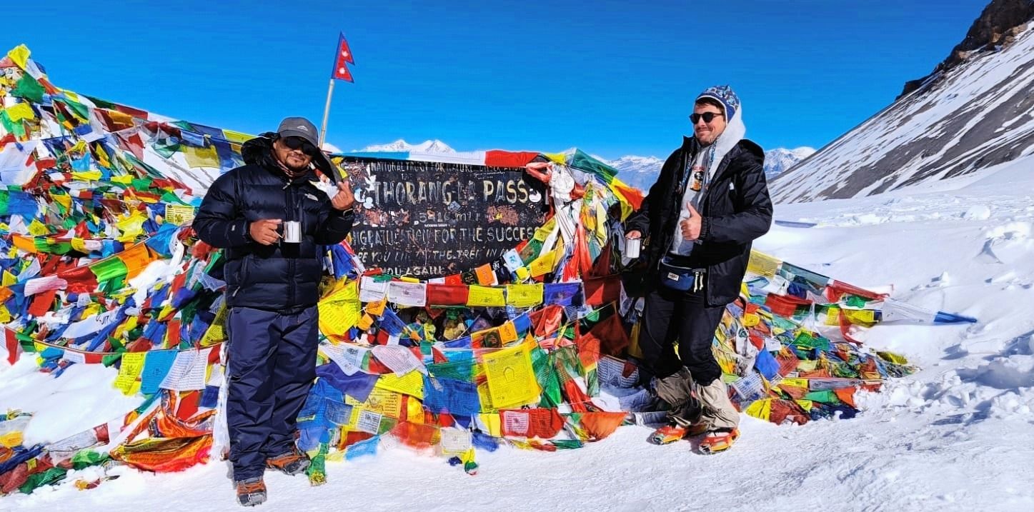
Trek From Thorong Phedi To Muktinath(3,800m) Passing Thorong La Pass(5,416m)
Trek Distance: 15 km. Trek Duration: 8-9 hrs. Elevation Gain/Loss: +876m ascent to the pass/-1,616 descent to Muktinath Today is the highlight of your Annapurna Circuit Trek-the legendary crossing of Thorong La Pass , the highest point of the trail. You wake up in the early pre-dawn chill, bundled in layers, ready to tackle the steep ascent. The world is quiet, with only the crunch of your boots on the snow/ice-dusted trail and the occasional flicker of headlamps guiding you upward. From High Camp(4,860m) or Thorong Phedi(4,450m) , the trail climbs steadily but sharply, zigzagging across the barren mountainside. The air is thin, and each breath reminds you of the high altitude. Yet the anticipation and exhilaration keep you moving. As the sun rises, the snow-covered peaks of Annapurna, Dhaulagiri(8,167m), the world 7th highest peak and Nilgiri light up in gold and pink-an unforgettable spectacle. After several hours of steady trekking, you finally reach Thorong La Pass(5,416m) . Standing here, you are on top of the world. Prayer flags flutter in the icy wind , and you take a moment to soak in the 360-degree panorama of the Himalayas stretching endlessly in every direction. This is the moment of triumph, achievement and awe-a memory that will stay with you forever . This day combines physical challenge, spiritual experience and unparalleled Himalayan scenery , making the pinnacle of your Annapurna Circuit adventure . Once you've taken photos, rested and celebrated, the journey continues downhill to Muktinath(3,800m) . The descent is long but scenic, winding past barren valleys, small glaciers and isolated settlements . The trail gradually opens into the sacred village of Muktinath , home to one of Nepal's most revered Hindu and Buddhist Pilgrimage sites, where the 108-water spouts of the temple offer a spiritual welcome. By late afternoon, you arrive in Muktinath, tired but fulfilled and settle into a cozy teahouse. Here, you can enjoy a well-earned meal and reflect on the extraordinary achievement of crossing one of the highest trekking passes in the world.
Day 11
Trek From Muktinath To Jomsom(2,720m) Then Drive To Tatopani(1,200m)
Trek Distance: 15 km.(Muktinath - Jomsom) Trek Duration: 5-6 hours.(Muktinath - Jomsom) Drive Distance: 90 km.(Jomsom - Tatopani) Drive Duration: 4 hours Elevation Loss: -2,600m. Leaving the sacred temple town of Muktinath , you begin a gentle descent into the windswept valleys of Mustang . The trail passes through ancient villages like Jharkot and Kagbeni , where Tibetan culture and centuries-old monasteries bring a timeless charm to the landscape. Waking along the banks of the Kali Gandaki River , you're surrounded by dramatic cliffs, wide barren valleys and views of Nilgiri and dhaulagiri standing tall in the distance. Reaching Jomsom, the administrative hub of Mustang , you'll then take a scenic drive down the world's deepest gorge, the Kali Gandaki . The road winds past apple orchards in Marpha , thundering waterfalls and rocky canyons before dropping into a lush, subtropical valley . By late afternoon, you arrive in Tatopani , where the natural ho springs by the riverside invite you to relax and rejuvenate after your high mountain journey .
Day 12
Trek From Tatopani To Ghorepani(2,860m)
Trek Distance: 16 km. Trek Duration: 6-7 hours. Elevation Gain: +1,660m. From the warm subtropical valley of Tatopani , famous for its natural hot springs, the trail begins a steady ascent into the heart of the Annapurna region . You climb through lush forests of rhododendron, oak and pine , stepping along stone-paved paths and occasional suspension and wooden bridges . Along the way, you'll pass traditional Magar villages like Dana(1,250m), Chitre(1,600m), Sikha(1,900m), Banthanti(2,150m) , terraced farmlands and cascading waterfalls that bring the forest alive. As you gain altitude, the vegetation changes to alpine shrubs and panoramic views of peaks like Annapurna South(7,219m), Hiunchuli(6,442m) and Machhapuchhre(6,993m) start to appear. The final approach to Ghorepani rewards trekkers with a charming village perched on a ridge, offering spectacular views of the surrounding Himalayan giants .
Day 13
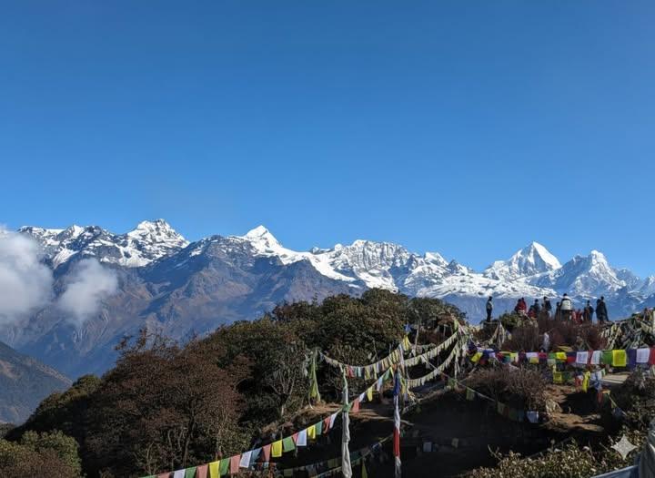
Hike Poon Hill(3,210m), Trek To Tikhedhunga(1,540m) Then Drive To Pokhara(823m)
Hiking Distance: 3 km(round trip), Duration: 1.5 hours. Trek Distance: 12 km. Trek Duration: 4-5 hours Drive Distance: 55 km(3 hours) Elevation Loss: -2,387m. Wake up early in the crisp mountain air of Ghorepani for the iconic hike to Poon Hill , one of Nepal's most breathtaking viewpoints . As the first rays of sunrise illuminate the towering peaks of Annapurna South(7,219m), Dhaulagiri(8,167m); the world's 7th highest peak, Fishtail(6,993m) and Hiunchuli(6,442m) , the valley below glows in golden in golden hues-a moment every trekker dreams of. After soaking in the panoramic vistas, descend through lush rhododendron and oak forests to the charming village of Tikhedhunga, passing traditional Magar settlements like Nangethanti, Banthanti, Ulleri and terraced farmlands. From Tikhedhunga , enjoy a scenic drive through the hills and riverside roads to Pokhara , where the adventure concludes with a well-earned rest in the lakeside city, reflecting on the unforgettable journey through Nepal's diverse landscapes, cultures and Himalayas . Upon arrival in Pokhara, the vibrant lakeside town welcomes you with comfortable hotels, cafes and the serene Phewa Lake. Here, you can relax, celebrate your achievement and reflect on the adventure that took you from Himalayas passes, sacred temples, alpine villages and awe-inspiring landscapes .
Day 14
Drive From Pokhara To Kathmandu(1,350m)
Drive Distance: 200 km. Drive Duration: 7-8 hours Elevation Gain: + 527m. After an unforgettable trek, relax on a scenic drive from Pokhara to Kathmandu along the winding Prithvi Highway. The journey takes you through lush valleys, terraced farmlands and riverside villages, with glimpses of the Himalayan foothills along the way. Passing charming town and local markets, this drive offers a perfect opportunity to soak in Nepal's natural beauty before arriving in the bustling capital. Overnight at a 4 star hotel in Kathmandu Farewell dinner with traditional cultural dances at 7pm in Kathmandu.
Day 15
Fly Back To Home Country.
Transfer to the Airport, included. Our team will drop you at the airport after farewell with an unforgettable experience of Annapurna Circuit Adventure. Thank you very much for being with us.
Day 1
Arrival In Kathmandu(1,350m)
Our team will be waiting for you at Tribhuvan International Airport in Kathmandu to welcome you with garlands of marigold flowers. And you will drive to your hotel by private vehicle. Trek briefing by our team and last-minute gear shopping. Explore: Thamel's vibrant streets, traditional markets, visit Boudhanath/Swayambhunath if you arrived in time. Vibe: Buzzing cultural atmosphere, pre-trek excitement. Overnight at a 4 star hotel in Kathmandu.
Day 2
Drive From Kathmandu To Jagat(1,300m)
Drive Distance: 210 km. Drive Duration: 7-8 hrs. Elevation Loss: -50m. You leave Kathmandu early in the morning and drive along the Prithvi Highway , following the Trishuli River through terraced fields and rolling green hills. As the journey continues, you begin to see glimpses of snowcapped peaks in the distance. After reaching Besisahar , the road becomes rougher and winds through the Marsyangdi Valley , passing waterfalls, forests, and small Gurung and Magar villages . By late afternoon, you arrive in Jagat, a traditional stone-paved village where you spend your first night on the Annapurna Circuit.
Day 3
Trek From Jagat To Dharapani(1,960m)
Trek Distance: 14 km. Trek Duration: 6-7 hrs. Elevation Gain: +660m. You start your morning in the charming stone-paved lanes of Jagat , where the sound of the Marsyangdi River guides you along the trail. As you set off, you descend briefly through subtropical forests , then begin a steady climb past scattered farms and small hamlets. The path winds through terraced fields of maize, barley and rice giving you a glimpse into the traditional lifestyle of the Gurung and Magar communities . Soon, you reach Chamje , a village that clings to the steep valley side, marked by waterfalls cascading down rocky cliffs . Crossing a suspension bridge , you feel the thrill of walking above the roaring river before continuing into dense forests filled with bamboo, pine and the occasional troop of langur monkeys . The trail climbs steadily toward Tal Village(1,700m) , the first village of the Manang District . Here, the valley suddenly opens into a wide, flat plain where the river calms into a serene flow. Tal's cluster of stone houses , waterfalls tumbling from the cliffs and prayer flags fluttering in the breeze make it one of the most scenic stops of the day. You pause here for a well-deserved rest or lunch, soaking in the dramatic landscape . From Tal, the trail continues gently upward along the Marsyangdi River , weaving through pine forests and smaller settlements like Khotro and Karte . The sound of prayer wheels turning and the sight of mani walls remind you that you are entering the Buddhist cultural heart of the Himalayas . By late afternoon, you arrive in Dharapani(1,960m) , a larger village where trekkers from the Annapurna Circuit and the Manaslu Circuit often cross paths. Surrounded by pine forests and stone-built houses , Dharapani welcomes you with warm teahouses, hot meals and the satisfactions of completing your first full day on the trail.
Day 4
Trek From Dharapani To Chame(2,670m)
Trek Distance: 15 km. Trek Duration: 6-7 hrs. Elevation Gain: +710m. You wake up in Dharapani to the crisp mountain air and the sound of prayer flags fluttering . Leaving the village behind, you follow a winding trail through dense forests of pine, oak and maple . The river continues to rush alongside you, its turquoise water cutting through the valley as you gradually gain altitude. As you pass through Bagarchhap , you notice the change in culture-Tibetan-style stone houses , colorful prayer flags and small Buddhist stupas that signal your entry deeper into the Manang region . The air feels cooler and the landscape begins to shift from lush greenery to alpine terrain . Climbing steadily, you make your way to Timang(2,320m) , a village perched on a ridge that rewards you with breathtaking views of Manaslu-8,163m(the world 8th highest peak) and the surrounding peaks. Here, you pause for lunchManaslu-8,163m(the world 8th highest peak) and the surrounding peaks. Here, you pause for lunch break, soaking in the stunning Himalayan panorama. From Timang , the trail continues through forests of pine and fir, with the scent of resin filling the air. The path undulates, leading you through small settlements like Thanchok before gently descending into the wide valley where Chame(2,670m) lies. Chame, the headquarters of Manang District , is a lively hub with hot springs, bakeries and teahouses. Towering above the town, the sheer rock face known as Paungda Danda rises dramatically, creating one of the most iconic landscapes on the Annapurna Circuit . As you settle in for the night, you feel the trill of being surrounded by the mighty Himalayas-knowing the mountains will only grow closer and grander in the days ahead
Day 5
Trek From Chame To Lower Pisang(3,200m)
Trek Distance: 14 km. Trek Duration: 5-6 hrs. Elevation Gain: +530m. You leave Chame in the fresh morning air, following the Marsyangdi River deeper into the valley. The trail winds through tall pine forests and the crisp alpine scent accompanies you as the mountains rise ever higher around you. Soon, the massive curved rock wall of Paungda Danda comes into full view-a dramatic 1,500-merter cliff that looks like it has been sliced by a giant blade. This awe-inspiring natural wander becomes one of the highlights of the day. As you continue, the valley narrows and the trail hugs the cliffsides, crossing several suspension bridges above the roaring river . You pass small settlements where mani walls and prayer wheels remind you of the deep Buddhist roots of the Manang region . The higher you climb, the cooler and drier the air feels, signaling your gradual ascent into the rain shadow of the Annapurnas . After a steady but manageable trek, the valley opens wide, revealing spectacular views of Annapurna II(7,937m), Annapurna IV(7,525m) and Pisang Peak(6,091m) . The scenery shifts from dense forest to more rugged alpine landscapes with scattered juniper bushes and wide grazing pastures . By mid to late afternoon, you reach Lower Pisang(3,200m) , a traditional Tibetan-style village of flat-roofed stone houses surrounded by fields of barley and buckwheat . From here, you are greeted with sweeping views of the Annapurna range glowing golden in the evening sun. Lower Pisang offers a peaceful atmosphere, cozy teahouses and the first real feeling of being deep in the Himalayas.
Day 6
Trek From Lower Pisang To Manang Village(3,540m)
Trek Distance: 16 km(depends on routes) Trek Duration: 6-7 hrs. Elevation Gain: +340m. You wake up in Lower Pisang to a crisp alpine morning, the peaks of Annapurna II(7,937m), Annapurna III(7,555m), Annapurna IV(7,525m) and Pisang Peak(6,091m) glowing in the first light. Today's trek is one of the most scenic on the entire circuit and you have two route options: Lower Route(via Humde - shorter, easier): A gentler trail following the valley floor along the Marsyangdi River, passing small villages and the airstrip at Humde. Upper Route(via Ghyaru and Ngawal-longer, tougher, more rewarding): A steep climb up to ancient Tibetan-style villages perched high on the ridge, offering breathtaking panoramas of the Annapurna range and the entire valley below. Eventually, both trails meet again near Mungji and Braka , where you pass ancient Buddhist monasteries and long mani walls carved with prayers . The trail flattens as you make your final approach to Manang(3,540m) , a vibrant trading village and the cultural heart of the region . Manang is surrounded by towering peaks and sits in the dry, high-altitude valley of the Annapurnas . Here, you find cozy teahouses, bakeries and a lively atmosphere where trekkers and locals mingle. You feel a sense of accomplishment as you settle in, knowing you're now at the doorstep of the higher Himalayas. This day is a visual feast of mountain panoramas, Buddhist culture and traditional villages -making it one of the highlights of the Annapurna Circuit .
Day 7
Acclimatization Day In Manang
Today is your rest and acclimatization day in Manang , an essential pause to help your body adjust to the higher altitude before you ascend further toward Thorong La Pass . But don't worry-rest day doesn't mean boredom. In fact, Manang is one of the most fascinating villages on the circuit and you'll have plenty to see and do. You begin the morning with a relaxed walk through the stone-paved alleys of the village, lined with traditional Tibetan-style houses, chortens and prayer walls . The Annapurna range towers directly above, with Gangapurna Glacier and its turquoise glacial lake shining brightly nearby. For acclimatization, you can choose from several rewarding short hikes: Gangapurna Lake(3,800m): A gentle walk to the stunning turquoise lake at the foot of the Gangapurna Glacial, offering a close-up view of the icy giants. Milarepa's Cave(4,000m): A steep hike across the river to a sacred meditation cave linked to the Tibetan saint Milarepa, with sweeping views back over the valley. Ice Lake(4,600m) - Full-day option: A tougher climb, but if you're feeling energetic , the views of Annapurna II, III, IV, Gangapurna and Tilicho Peak from here are truly unforgettable. In the afternoon, you can relax at one of Manang's cozy bakeries with apple pie and coffee , visit the monasteries or explore the Himalayan Rescue Association's information center to learn about altitude sickness and mountain safety. As the sun sets, you find yourself surrounded by mountains glowing golden-Annapurna III(7,555m), Gangapurna(7,455m), Tilicho Peak(7,134m) and Chulu Peaks -and you feel deeply grateful for this pause in such a dramatic Himalayan amphitheater . This day gives you the chance to rest explore and prepare-both physically and mentally-for the higher trails and the crossing of Thorong La Pass ahead.
Day 8
Trek From Manang Village To Yak Kharka(4,020m)
Trek Distance: 10 km. Trek Duration: 4-5 hrs. Elevation Gain: +480m. After a refreshing acclimatization day in Manang, you begin your ascent toward the higher valleys. The trail climbs gently out of the village, leaving behind terraced fields and stepping into a drier, harsher landscape where shrubs replace forests and the air grows thinner. You feel the change with every step-the high Himalayas are now truly within reach. The path leads you through Tengi and Gunsang , small settlements with traditional stone houses and fluttering prayer flags . From here, the trail rises steadily along the valley side, offering wide views of the Annapurna range . Tilicho Peak(7,134m) and Chulu West(6,419m) . The scenery feels vast and open, with the Marsyangdi River far below and snow-capped peaks pressing close above. The trek is shorter today by design, allowing your body to continue adjusting to the higher elevation. You take it slowly, enjoying the stark beauty of this alpine region-where yaks graze on sparse pastures, blue sheep may appear on slopes and Himalayan eagles soar overhead. By early afternoon, you arrive at Yak Kharaka , a windswept settlement that lives up to its name as a yak-grazing pasture . Here, the mountains feel almost within touching distance and the crisp thin air reminds you that you've entered the true high-altitude world of the Annapurnas. You spend the night in a cozy teahouse, resting well in preparation for the tougher climbs ahead.
Day 9
Trek From Yak Kharka To Thorong Phedi(4,540m)
Trek Distance: 7 km. Trek Duration: 4-5 hrs. Elevation Gain: +520m. You set out from Yak Kharka after breakfast, feeling the crisp chill of the thin mountain air. The trail begins with a gradual climb along the valley, following the Jarsang Khola(river) . The landscape is stark but beautiful-brown hillsides dotted with juniper shrubs, grazing yaks and the occasional cluster of stone-built teahouses . Above you, the snowy peaks of Gundang(5,312m), Syagang(6,026m) and Thorong Peak(6,144m) glisten in the sunlight, reminding you of the heights still to come. The path is steady but demands patience. You cross two suspension bridges , then climb a narrow trail cut into the hillside where the terrain becomes more rugged. The valley narrows and you carefully watch you footing as loose stones crunch beneath your boots. With every step, the sense of anticipation grows-you are now very close to Thorong La, the highest point of your trek . After 3-4 hours of walking at a slow, steady pace, you reach Thorong Phedi(4,450m) , a small settlement tucked at the foot of the massive pass. The word "Phedi" means "base" and this is exactly what the village feels like-a final resting point before tomorrow's big climb. Most trekkers stop here to rest, but if you're feeling strong and well-acclimatized, you can push another hour higher to High Camp(4,880m) , which makes the next day's pass crossing a bit shorter. Wherever you stay, you spend the afternoon relaxing, hydrating and preparing mentally for the challenge of crossing Thorong La Pass-one of the highest trekking passes in the world .
Day 10
Trek From Thorong Phedi To Muktinath(3,800m) Passing Thorong La Pass(5,416m)
Trek Distance: 15 km. Trek Duration: 8-9 hrs. Elevation Gain/Loss: +876m ascent to the pass/-1,616 descent to Muktinath Today is the highlight of your Annapurna Circuit Trek-the legendary crossing of Thorong La Pass , the highest point of the trail. You wake up in the early pre-dawn chill, bundled in layers, ready to tackle the steep ascent. The world is quiet, with only the crunch of your boots on the snow/ice-dusted trail and the occasional flicker of headlamps guiding you upward. From High Camp(4,860m) or Thorong Phedi(4,450m) , the trail climbs steadily but sharply, zigzagging across the barren mountainside. The air is thin, and each breath reminds you of the high altitude. Yet the anticipation and exhilaration keep you moving. As the sun rises, the snow-covered peaks of Annapurna, Dhaulagiri(8,167m), the world 7th highest peak and Nilgiri light up in gold and pink-an unforgettable spectacle. After several hours of steady trekking, you finally reach Thorong La Pass(5,416m) . Standing here, you are on top of the world. Prayer flags flutter in the icy wind , and you take a moment to soak in the 360-degree panorama of the Himalayas stretching endlessly in every direction. This is the moment of triumph, achievement and awe-a memory that will stay with you forever . This day combines physical challenge, spiritual experience and unparalleled Himalayan scenery , making the pinnacle of your Annapurna Circuit adventure . Once you've taken photos, rested and celebrated, the journey continues downhill to Muktinath(3,800m) . The descent is long but scenic, winding past barren valleys, small glaciers and isolated settlements . The trail gradually opens into the sacred village of Muktinath , home to one of Nepal's most revered Hindu and Buddhist Pilgrimage sites, where the 108-water spouts of the temple offer a spiritual welcome. By late afternoon, you arrive in Muktinath, tired but fulfilled and settle into a cozy teahouse. Here, you can enjoy a well-earned meal and reflect on the extraordinary achievement of crossing one of the highest trekking passes in the world.
Day 11
Trek From Muktinath To Jomsom(2,720m) Then Drive To Tatopani(1,200m)
Trek Distance: 15 km.(Muktinath - Jomsom) Trek Duration: 5-6 hours.(Muktinath - Jomsom) Drive Distance: 90 km.(Jomsom - Tatopani) Drive Duration: 4 hours Elevation Loss: -2,600m. Leaving the sacred temple town of Muktinath , you begin a gentle descent into the windswept valleys of Mustang . The trail passes through ancient villages like Jharkot and Kagbeni , where Tibetan culture and centuries-old monasteries bring a timeless charm to the landscape. Waking along the banks of the Kali Gandaki River , you're surrounded by dramatic cliffs, wide barren valleys and views of Nilgiri and dhaulagiri standing tall in the distance. Reaching Jomsom, the administrative hub of Mustang , you'll then take a scenic drive down the world's deepest gorge, the Kali Gandaki . The road winds past apple orchards in Marpha , thundering waterfalls and rocky canyons before dropping into a lush, subtropical valley . By late afternoon, you arrive in Tatopani , where the natural ho springs by the riverside invite you to relax and rejuvenate after your high mountain journey .
Day 12
Trek From Tatopani To Ghorepani(2,860m)
Trek Distance: 16 km. Trek Duration: 6-7 hours. Elevation Gain: +1,660m. From the warm subtropical valley of Tatopani , famous for its natural hot springs, the trail begins a steady ascent into the heart of the Annapurna region . You climb through lush forests of rhododendron, oak and pine , stepping along stone-paved paths and occasional suspension and wooden bridges . Along the way, you'll pass traditional Magar villages like Dana(1,250m), Chitre(1,600m), Sikha(1,900m), Banthanti(2,150m) , terraced farmlands and cascading waterfalls that bring the forest alive. As you gain altitude, the vegetation changes to alpine shrubs and panoramic views of peaks like Annapurna South(7,219m), Hiunchuli(6,442m) and Machhapuchhre(6,993m) start to appear. The final approach to Ghorepani rewards trekkers with a charming village perched on a ridge, offering spectacular views of the surrounding Himalayan giants .
Day 13
Hike Poon Hill(3,210m), Trek To Tikhedhunga(1,540m) Then Drive To Pokhara(823m)
Hiking Distance: 3 km(round trip), Duration: 1.5 hours. Trek Distance: 12 km. Trek Duration: 4-5 hours Drive Distance: 55 km(3 hours) Elevation Loss: -2,387m. Wake up early in the crisp mountain air of Ghorepani for the iconic hike to Poon Hill , one of Nepal's most breathtaking viewpoints . As the first rays of sunrise illuminate the towering peaks of Annapurna South(7,219m), Dhaulagiri(8,167m); the world's 7th highest peak, Fishtail(6,993m) and Hiunchuli(6,442m) , the valley below glows in golden in golden hues-a moment every trekker dreams of. After soaking in the panoramic vistas, descend through lush rhododendron and oak forests to the charming village of Tikhedhunga, passing traditional Magar settlements like Nangethanti, Banthanti, Ulleri and terraced farmlands. From Tikhedhunga , enjoy a scenic drive through the hills and riverside roads to Pokhara , where the adventure concludes with a well-earned rest in the lakeside city, reflecting on the unforgettable journey through Nepal's diverse landscapes, cultures and Himalayas . Upon arrival in Pokhara, the vibrant lakeside town welcomes you with comfortable hotels, cafes and the serene Phewa Lake. Here, you can relax, celebrate your achievement and reflect on the adventure that took you from Himalayas passes, sacred temples, alpine villages and awe-inspiring landscapes .
Day 14
Drive From Pokhara To Kathmandu(1,350m)
Drive Distance: 200 km. Drive Duration: 7-8 hours Elevation Gain: + 527m. After an unforgettable trek, relax on a scenic drive from Pokhara to Kathmandu along the winding Prithvi Highway. The journey takes you through lush valleys, terraced farmlands and riverside villages, with glimpses of the Himalayan foothills along the way. Passing charming town and local markets, this drive offers a perfect opportunity to soak in Nepal's natural beauty before arriving in the bustling capital. Overnight at a 4 star hotel in Kathmandu Farewell dinner with traditional cultural dances at 7pm in Kathmandu.
Day 15
Fly Back To Home Country.
Transfer to the Airport, included. Our team will drop you at the airport after farewell with an unforgettable experience of Annapurna Circuit Adventure. Thank you very much for being with us.


Uncover Hidden Wilderness Together!
Often celebrated as a harmonious union of physical activity and natural exploration become an enriching journey for both body and mind.
