Menu
16 Days
Manaslu Circuit Trek Via Mamche Pass
The Manaslu Circuit Trek via Mamche Danda offers a unique alternative to the standard route by starting from Barpak Village, the epicenter of the 2015 earthquake. This route provides a deeper cultural experience, passing through Gurung, Tibetan, and mixed ethnic villages, this off-the beaten-path trek offers diverse landscapes, Tibetan Buddhist culture, the communities of nature worshiper, and thrilling Larkya La Pass(5,160m), breathtaking views of Manaslu (8,163m); the 8th highest peak in the world, Himalchuli (7,893m), Ngadi Chuli (7,871m), and Ganesh Himal Range(Ganesh Nw7,118m, Chamar-7,100m Pabil-7,104m, Yangra-7,422m, Salasungo-7,043m) , Bauddha Himal-6,672m, Langtang Lirung-7,227m. This trek is perfect for adventure lovers seeking culture, nature, and high-altitude challenges. Let's do this trek with Gurkhas Mountain Adventure for your life time experience. GROUP PRICE BREAKDOWN: *1pax = $1,450/pax *2-4pax = $1,350/pax *5-7pax = $1,200/pax *8-10pax = $1,100/pax *11-14pax = $1,050/pax *Above 15pax =$1000/pax
18
Minimum Age
Western Nepal(MCAP and ACAP)
Location
$1100.00
Per Person
Overview
The Manaslu Circuit Trek via Mamche Pass is one of Nepal's most spectacular and culturally authentic Himalayan adventures, encircling the world's eighth-highest mountain, Mt. Manaslu(8,163m). This route unfolds along the Daraudi Khola and Budhi Gandaki Valley, across ancient villages, Buddhist monasteries, lush forests and over the majestic Larkya La Pass(5,160m).
Adding the Mamche Pass(2,900m) section makes this version especially unique - it begins from Barpak Village, the legendary home of Gurkha soldiers and the epicenter of Nepal's 2015 earthquake, offering a more scenic and historical entry into the Manaslu region. The trek is a blend of natural grandeur, cultural richness and spiritual depth, making it one of the most rewarding journeys in Nepal's restricted trekking areas.
Trek at a Glance:
Region: Manaslu Conservation Area(MCAP) & Annapurna Conservation Area Project(ACAP).
Trek Duration: 14 Days.
Max Elevation: 5,160m(Larkya La Pass).
Trek Distance: Approx. 180 km.
Starting Point: Kathmandu - Barpak
Ending Point: Dharapani - Kathmandu
Difficulty Level: Moderate to Challenging
Accommodation: Teahouses/Lodges.
Best Seasons: March - May & September - November.
Historical & Cultural Significance:
The name "Manaslu" comes from the Sanskrit word Manasa, meaning "soul" or "spirit", symbolizing the Mountain of the Spirit. The region was opened to foreign trekkers only in 1991, preserving its pristine nature and ancient Tibetan-influenced culture. Along the trail, you encounter centuries-old monasteries, mani walls and chortens, reflecting the deep-rooted Buddhist faith of the Nubri and Tsum people. Villages like Sama Gaon and Samdo still practice traditional Tibetan lifestyles, language and festivals such as Lhosar(Tibetan New Year) and Mani Rimbu.
Landscapes & Scenery:
The trek traverses one of the most varied landscapes in Nepal - from subtropical hills to arid alpine valleys. You'll journey through:
Terraced rice fields and rhododendron forests in the lower region.
Deep gorges carved by the roaring Budhi Gandaki River.
High Himalayan meadows and glacial valleys near Lho, Samagaon and Bhimtang.
Snow-covered passes and dramatic icefalls beneath towering peaks.
The view from Larkya La Pass(5,160m) is breathtaking - a sweeping panorama of Himalchuli(7,893m), Manaslu(8,163m), Ngadi Chuli(7,871m), Cheo Himal(6,820m), Himlung Himal(7,126m) and Annapurna II(7,937m).
Major Peaks Visible:
Manaslu(Kutang-8,163m)
Himalchuli(7,893m)
Ngadi Chuli(Peak 29-7,871m)
Buddha Himal(6,672m)
Cheo Himal(6,820)
Himlung Himal(7,126m)
Ganesh Himal(7,422m)
Annapurna II(7,937m)
Villages & Local Life:
The trek passes through traditional villages such as:
Barpak(1,920m): Gurung and Ghale heritage village, birthplace of the Gorkha soldiers.
Laprak(2,700m new settled village after the earthquake-2015, 2,100m old village): Rebuilt after the 2015 earthquake, rich in Gurung culture and home to mountaineers.
Singla, Khorla, Khorlabesi & Jagat: Warm hill villages surrounded by crops terraces and waterfalls.
Namrung(2,630m): First glimpses of Tibetan-style architecture and monasteries.
Lho Gaon(3,180m): Known for Ribung Monastery and incredible views of Manaslu.
Sama Gaon(3,530m): Cultural and spiritual heart of the trek; gateway to Manaslu Base Camp(4,800m).
Samdo(3,875m): Last Tibetan village before the pass, near the Tibetan border.
Bhimtang(3,720m): Beautiful post-pass valley surrounded by glaciers.
Route Outline(16 Days):
Arrival in Kathmandu(1,350m).
Drive to Barpak(1,920m)-7 hours drive
Trek From Barpak - Laprak(2,100m) via Mamche Pass(2,900m).
Laprak - Khorlabesi(975m).
Khorlabesi - Jagat(1,340m).
Jagat - Deng(1,860m).
Deng - Namrung(2,630m).
Namrung - Lho Gaon(3,180m).
Lho Gaon - Sama Gaon(3,530m).
Rest/Acclimatization at Sama Gaon - hike to Manaslu Base Camp(4,800).
Sama Gaon - Samdo (3,875m).
Samdo - Dharamshala(4,460m).
Cross Larkya La Pass(5,160m) - Bhimtang(3,720m).
Bhimtang - Tilche(2,300m)/Dharapani(1,920m).
Tilche/Dharapani - Kathmandu drive.
Departure.
Flora & Fauna:
The Manaslu Conservation Area is a biodiversity hotspot, home to:
Wildlife: Snow leopard, Himalayan Thar, Blue sheep, musk deer, langur monkeys and red panda.
Birds: Golden eagles, blood pheasants, snow cocks and Himalayan griffons.
Flora: Rhododendron, juniper, fir, pine, birch and medicinal plants such as yarsagumpa and jatamasi.
Vegetation Zones:
Subtropical Zone(1000-2000m): Sal trees, ferns and bamboo.
Temperate Zone(2000-3000m): Rhododendron, oak and pine forests.
Subalpine Zone(3000-4000m): Birch, juniper and hemlock.
Alpine Zone(4000-5000m): Shrubs and alpine meadows.
Nival Zone(Above 5000m): Glaciers, snow and ice terrain.
Temperature By Season:
Spring(Mar-May): 10-25DC(Day)/0-10DC(Night)
Summer(Jun-Aug): 15-30DC(Day)/5-15DC(Night)
Autumn(Sep-Nov): 10-20DC(Day)/-5-5DC(Night)
Winter(Dec-Feb): 5-15DC(Day)/ -10 to -20DC(Night)
Permits Required:
You need special permits because it's a restricted area:
Manaslu Restricted Area Permit(MRAP).
Manaslu Conservation Area Permit(MCAP).
Annapurna Conservation Area Permit(ACAP).
Must trek with licensed trek guide.
Minimum 2 trekkers(official rule).
Accommodation:
Mostly teahouses/lodges
Basic but improving facilities: Twin rooms, shared bathrooms and simple meals.
Food:
Dal Bhat(rice, lentils, vegetables).
Noodles, fried rice, pasta.
Tibetan bread, pancakes, chapati, spring rolls
Tea, coffee, hot lemon.
Challenges:
High altitude risk(AMS).
Long walking days.
Limited infrastructure compared to Everest region.
Weather unpredictability at high pass.
Essential Packing:
Warm layers(down jacket, thermals).
Waterproof gear.
Good trekking boots.
Sleeping bag(-10DC recommended)
Trekking poles.
Water purification.
Documents & Money:
· Passport with Nepal visa)
· Travel insurance copy (including helicopter rescue).
· Cash in nepali currency 15,000 – 20,000 rupees for extra expenses during your trek 'coz there isn't
any ATM on the trail.
Optional but Useful:
· Lightweight crampons
Why Choose the Manaslu Circuit Trek via Mamceh Pass?
Offers both cultural immersion and high-mountain adventure.
Less crowded than Annapurna or Everest regions.
Includes the scenic Mamche Pass route through authentic Gurung villages.
Spectacular views of Manaslu, Boudha Himal, Himalchuli and Ganesh Himal throughout.
Rich Tibetan culture, wildlife and pristine landscapes.
A restricted-area trek, ensuring preservation and exclusivity.
Fewer tourists, more authenticity and deeper connections.
Flights & Drives:
Kathmandu - Barpak: 6-7 hours scenic drive via historical Gorkha Bazaar.
Tilche - Dharapani - Besisahar - Kathmandu: 8-9 hours drive on the return.
No flight available on this route.
Trail Condition:
The Manaslu Circuit trail is a combination of stone steps, forest paths, suspension bridges and rocky sections. It is well-maintained and safe, though some sections(especially near Larkya La Pass) can be snowy in early spring and winter.
Gurkhas Mountain Adventure for your life time experience.
GROUP PRICE BREAKDOWN:
*1pax = $1,450/pax
*2-4pax = $1,350/pax
*5-7pax = $1,200/pax
*8-10pax = $1,100/pax
*11-14pax = $1,050/pax
*Above 15pax =$1000/pax
Trip Details
Trip Duration
16 days
Max Altitude
5160 m
Trip Difficulty
Challenging
Accommodation
Lodges and Teahouses
Best Season
Spring: March-May, Autumn: September - November
Meals
Included
Nearest Airport
xxx
Local Transport
Jeep, Bus, Horse, Donkey, Yaks
Manaslu Circuit Trek Via Mamche Pass
Day 1
Arrival In Kathmandu(1,350m)
Our team(trek guide/representatives) will be waiting for you at Tribhuvan International Airport in Kathmandu with garland of marigold flowers to have a warm welcome in the land of mountains. Transfer to hotel by a private car/vehicle then you will be briefing for preparation of the trek, shopping and rest time. Explore: Thamel's vibrant streets, traditional markets, visit Boudhanath/Swayambhunath if you arrived in time. Vibe: Buzzing cultural atmosphere, pre-trek excitement. Overnight at a 4 star hotel at Thamel in Kathmandu.
Day 2
Drive From Kathmandu To Barpak(1,900m)
Drive Distance: 150 km. Drive Duration: 8-9 hrs. Elevation Gain: +550m. Around 7:30am you'll leave your hotel and drive west along the Prithvi Highway , following the Trishuli River through green valleys, terraced hills and views of snow capped mountains . At Abukhaireni, you'll turn to the right, leaving the Pokhara highway behind. From here, the road climbs into the Gorkha region , winding past villages, forests and steep hillsides. The stretch is rough and narrow but every turn brings wider views. After about 8-9 hours of driving you'll reach at Barpak Village(1,900m) , Traditional Gurung and Ghale village with stunning views of Bauddha Himal(6,672m) . Reach the Earthquake-epicentr-2015 with resilient spirit. Overnight at a lodge in Barpak village.
Day 3
Trek From Barpak Village To Laprak Village(2,200m) Via Mamche Pass(2,910m)
Trek Distance: 9 km. Trek Duration: 5-6 hrs. Elevation Gain : +1010m at Mamche pass and +300m at Laprak village. You leave Barpak , the hillside Gurung and Ghale village famous for its resilience and stone-roofed houses , with the white summit of Boudha Himal(6,672m) gleaming above you. The trail reses gently at first through some terraced fields and slope hills, where local people greet you with a smile as they walking on the trail. As you climb higher, you step into cool forests of rhododendron and others. The air grows fresher and birdsong fills the silence. After a steady uphill push, you arrive at the broad ridge of Mamche Danda(2,850m) . Here, you pause to have a cup of hot drinks, where the world opens in all directions: to the north, the snow giants of Boudha Himal(6,672m), Himalchuli(7,893m), Sringi Himal(7,187m), Ganesh Himal range(Chamar-7,100m, Ganesh Nw-7,118m, Yangra-7,422m, Pabil-7,104m, Salasungo-7,043m) and Langtang Lirung(7,227m) rise in crystal clarity; to the south, rolling mid-hills stretch endlessly into the horizon. It feels as though you are standing on a natural balcony above the Himalayas. From Mamche after walking 20 minutes straight beside the weaving down through meadows, shepherd huts and whispering forests. the trail drops steeply and you'll pass the new Laprak village at Gupsipakha (settled after the Earthquake-2015) . Having a lunch at the new village, your trek will continue down to old Laprak village . You'll see Laprak spread out across a s loping hillside-a patchwork of stone houses, prayer flags and terraced fields glowing golden in the afternoon sun. By the time you step into the narrow stone lanes of Laprak(2,200m) , children run to greet you, and smoke rises from kitchen hearths. You feel as though you've entered a timeless Gurung settlement, where tradition and nature live in perfect balance.
Day 4
Trek From Laprak To Khorla Besi(970m)
Trek Distance: 16 km. Trek Duration: 6-7 hrs. Elevation Loss: -1,130m. Your trek begins leaving the traditional Gurung village of Laprak , walking through stone lanes and terraced fields that glow in the morning light. The trail first descend downwards to Jerbu river then after crossing a suspension bridge over the river the trail steadily begins to ascend till Singla village(Ganesh Himal Range will be very closed to you) and down to Khorla village and Khorlabesi . As you descend, the sound of the Budhi Gandaki River grows louder below, echoing through the gorge. You pass small settlements and fields of maize and millet, meeting villagers carrying baskets or leading mules along the trail. The path takes you down into subtropical forest , where you cross streams and walk beneath bamboo groves. You can feel the change in climate as the air grows warmer and more humid. The trail undulates-steep drops followed by short climbs- testing your knees and stamina . Finally, you reach the river and follow it downstream until you arrive at Khorlabesi(970m) , a lively riverside village. Here, the temperature feels warmer and you're back among banana trees, cardamom gardens and the chatter of locals. Overnight at a lodge at Khorla Besi by the side of Budhi Gandaki river.
Day 5
Trek From Khorla Besi To Jagat(1,340m)
Trek Distance: 13 km. Trek Duration: 5-6 hrs. Elevation Gain: + 370m. After having your breakfast the trek starts walking along the Budhi Gandaki River as the valley narrows into a gorge. The trail rises and falls, winding through forested hillsides and rocky paths. Before long, you reach Tatopani-990m(Natural hot spring) , bubble beside the trail. You may stop for a quick soak or simply enjoy the steam rising from the riverbank. From Tatopani, you will be walking along the road till beside Dobhan(1,070m) , From where you cross a suspension bridge to reach Dobhan-a small settlement where mule trains often pass, avoid the edge during their passing. The sound of their bells mixes with the rushing river as you continue along the trail. The path then leads through forest and cliffs, sometimes carved directly into rock , offering dramatic views of waterfalls tumbling into the gorge below. As you walk, you feel the atmosphere shift-the valley becomes wilder and more remote. The final stretch is a steady climb on stone staircases until you arrive at Jagat(1,340m) , a beautifully paved stone village perched on a ridge above the Budhi Gandaki. This is also the official entry checkpoint for the Manaslu Conservation Area(MCAP) , Where you register your permits. Overnight at a lodge in Jagat.
Day 6
Trek From Jagat To Deng(1,860m.)
Trek Distance: 19 km. Trek Duration: 6-7 hrs. Elevation Gain: +520m. You begin your morning walking out of Jagat, a stone-paved village with mani walls and a conservation checkpoint . The trail immediately offers a mix of stone staircases, suspension bridges and forested paths . The Budhi Gandaki River roars below as you move along cliffside trails . Soon, you pass through Sirdibas(1,430m ), a small Buddhist village with prayer flags and peaceful vib e. The mani walls and chortens here remind you that you are slowly entering Tibetan-influenced territory . Crossing a long suspension bridge , you ascend to Philim(1,570m) , a lager Gurung village . Here, neat houses, terraced fields and school supported by Japanese aid give the village a unique character. It's a perfect place to rest, sip tea and enjoy wide valley views. Beyond Philim, the valley opens into golden fields, then narrows again into a gorge with sheer cliffs . You walk under rocky overhang , where the river squeezes through dramatic stone walls . At Ekle Bhatti , you find a teahouse junction-one trail leads toward Tsum Valley , while your path continues along the Manaslu Circuit . The trail winds through forested slopes with tall pines and bamboo , where you may hear the calls of langurs or spot colorful Himalayan birds . You continue past Nyak and cross several small s treams on wooden planks or suspension bridges . Finally, after a long but gradual climb along the riverbank, you reach Deng(1,860m) , a small village with Tibetan-style houses . Smoke rises from the kitchens and you sense you are now deeper in Buddhist territory . Overnight at a teahouse in Deng.
Day 7
Trek From Deng To Namrung(2,630m)
Trek Distance: 18 km. Trek Duration: 6-7 hrs. Elevation Gain: +770m. Your trek begins in the early morning, crossing a suspension bridge over the Budhi Gandaki Rive r. The trail climbs steadily through dark pine and fir forests, where the sound of the river echoes below and sunlight filters through the trees. The air feels cooler now-you're climbing higher into the Himalayas. Soon, you pass Bihi Phedi(2,130m) , a small settlement where children may run out to greet you. From here, you catch glimpses of Kutang Himal(7,923m) rising sharply to the north, its white peak gleaming in the distance. Prayer flags and mani walls remind you that you are entering deeper into Tibetan Buddhist territory . The trail then meanders through forests and farmlands dotted with potatoes, barley, and buckwheat . You continue past several small hamlets, following the river and crossing wooden and suspension bridges . The gorge here feels narrower and steeper, with the Budhi Gandaki surging between high cliffs. As you climb further, you reach Ghap(2,160m ), a picturesque village with mani walls and colorful chortens. This is a good place for lunch break. Beyond Ghap, the trail enters enchanting forests of fir, rhododendron and bamboo , where you may hear the hooting of Himalayan pheasants or see troops of gray langur monkeys . You cross the river several times on suspension bridges , each crossing bringing new perspectives of the gorge and surrounding peaks . The path climbs steadily through forested slopes and farmland until you finally arrive at Namrung(2,630m) . Namrung feels different-it is a gateway village with a strong Tibetan Buddhist presence . Stone houses , prayer wheels , carved mani stones and the friendly smiles of villagers welcome you. Overnight at a lodge in Namrung.
Day 8
Trek From Namrung To Lho Gaon(3,180m)
Trek Distance: 11 km. Trek Duration: 4-5 hrs. Elevation Gain: +550m. After having your breakfast, you leave Namrung , a stone-built Buddhist village where prayer wheels line the pathways and the morning sun strikes the snow peaks above. From the village, the trail climbs gently through forests or fir, rhododendron and oak , opening occasionally to reveal terraces of barley, potatoes and wheat . As you walk, the valley widens and you are rewarded with stunning views of Ganesh Himal, Himal Chuli(7,893m) and Mount Manaslu(8,163m) ; the world 8th highest peak, towering above. The trail passes through small hamlets where children smile shyly, and farmers tend to their high-altitude crops . You reach Lihi Gaon(2,900m ), a beautiful village surrounded by chortens, barley fields and mani walls . The trail continues with short climbs and descents across steams and landslide sections until you arrive at Sho Gaon(2,950m) , another peaceful settlement. Here, the first full views of the giant Mountain; Manaslu's north face appear , a breathtaking sight that reminds you why this trek is so special. Finnally, you arrive at Lho Gaon(3,180m) , a spectacular village dominated by the majestic Ribung Gompa Monastery , which sits above the village like a guardian. From Lho , you enjoy sweeping views of Manaslu, Himal Chuli and Ngadi Chuli glowing golden at sunset. Overnight at a lodge in Lho Gaon.
Day 9
Trek From Lho Gaon To Sama Gaon)3,530m)
Trek Distance: 12 km. Trek Duration: 5-6 hrs. Elevation Gain: +350m. You trek starts early in the morning from Lho Gaon , a village dominated by the imposing Ribung Monastery and backed by the mighty Manaslu(8,163m) glowing in the morning sun. As you leave the village, you follow a forested trail where rhododendrons, pines and oaks give you refreshing shade. The walk feels gentle at first and you keep looking back for stunning views of Manaslu and Manaslu North standing tall behind you. Soon, you pass small chortens, mani walls and prayer flags fluttering in the wind-each reminding you that you're deep in the Nubri Valley , where Tibetan Buddhist culture is alive and thriving. The trail ascends gradually and after about an hour, you reach Shyala Village(3,500m) . Here, you're treated to a panoramic amphitheater of peaks : Himal Chuli(7,893m), Ngadi Chuli(7,871m), Manaslu and Ganesh Himal all surround you. You pause here, amazed at the sheer scale of the mountains. From Shyal, the trail becomes more open and you cross yak pastures where you might see herders tending their animals. You pass through alpine meadows filled with wildflowers in spring, while in autumn, the golden colors of the landscape take over. The air feels thinner, but the beauty of the surroundings keeps you energy high. Continuing on, you pass through the charming settlement of Pungen Gompa trail junction (a side trip option to Pungen Monastery , an ancient meditation site with a glorious view of the Manaslu glacier). If you don't take the side trip, you continue along the main trail toward Sama Gaon . The path now follows the valley floor beside the Budhi Gandaki River , its icy blue water rushing below you. The sound of the river accompanies your steps as you approach the broad and fertile valley of Sama Gaon . Before you arrive, you cross cultivated field s where locals grow barley and potatoes and you see children playing near stone houses with wooden roofs . Finally, you step into Sama Gaon(3,530m) , one of the most significant villages on the Manaslu Circuit . Here, you find yourself surrounded by a breathtaking mountain panorama, dominated by Manaslu's east face towering above the village. Sama Gaon is rich in Tibetan culture with mani walls, old monasteries and traditional stone houses welcoming you into this highland world. Overnight at a lodge in Sama Gaon.
Day 10
Acclimatization Day At Sama Gaon
Optional Hiking Distance: 10 km round trip from Sama Gaon to Pungen Gompa(4,000m). Optional Hiking Distance: 10-12 km round trip from Sama Gaon to Manaslu Base Camp(4,800m) Hiking Duration: 4-5 hr for Pungen Gompa and 6-7 hrs for Base Camp. Elevation Gain: +470m at Pungen Gompa and +1,270m at Base Camp. Two Options for hiking: Pungen Gompa(4,000m) - Starts south of Sama Gaon, gradually ascends through yak pastures, Scenic views of Manaslu, glaciers and beautiful glacial valley and reach Pungen Gompa with panoramic mountainous views. Ideal acclimatization hike; fewer crowds than the base camp route. Manaslu Base Camp(4,800m) - Steep uphill trail starting from Sama Gaon heading north toward the Base Camp of Manaslu, you will pass the forests of birch and rhododendron, glacier moraines and icy streams. More challenging but rewarding hike; spectacular close-up views of Mt. Manaslu, glaciers, and potential sightings of Himalayan wildlife. Overnight at the same lodge in Sama Gaon.
Day 11
Trek From Sama Gaon To Samdo(3,860m)
Trek Distance: 8 km. Trek Duration: 4-5 hrs. Elevation Gain: +330m. You begin your trek in the crisp morning air of Sama Gaon, surrounded by the towering Manaslu(8,163m) to the west. The village itself is a cultural gem , with mani walls, chortens and stone houses that make you feel as if time moves slower here. As you leave Sama, the trail gently ascends through alpine meadows dotted with grazing yaks . You follow the Budhi Gandaki River , its icy waters rushing alongside, carving a deep gorge into steps, rocky trails and open meadows , giving you a sense of variety with each turn. The valley narrows as you continue and the terrain becomes more rugged . You cross a few wooden bridge over icy steams and the higher altitude makes each step feel more purposeful. The yak herders' settlements you pass give you glimpses of high-altitude Himalayan life-men in traditional Tibetan dress, yaks grazing and stone houses with prayer flags fluttering in the wind. Finally, after a gradual climb through rocky terrain and past small herder shelters, you arrive at Samdo(3,860m) . The village sits like a jewel at the base of Manaslu's glacier, surrounded by dramatic peaks and barren slopes. Samdo marks the beginning of the high-altitude section of the Manaslu Circuit and you immediately feel the thin air, the silent grandeur and the raw beauty of the Himalayas. Overnight at a teahouse in Samdo Village.
Day 12
Trek From Samdo To Dharmashala(4,460m)
Trek Distance: 7 km. Trek Duration: 4-5 hrs. Elevation Gain: +600m. You wake up at Samdo , surrounded by the raw grandeur of the Himalayas . The morning light illuminates Manaslu's east face , glaciers sparkling in the sun . As you step onto the trail, the air feels crisp, thinner and every breath reminds you of the altitude. The trail ascends gradually along rocky slopes and moraine-strewn paths . You pass through yak pastures where herders guide their flocks and notice traditional Tibetan-style houses perched precariously on the slopes. Prayer flags flap in the wind, offering a spiritual blessing for your journey. As you climb higher, the vegetation disappears, replaced by barren alpine terrain, glacial rocks and ice-melt steams . The path winds steadily upward toward Dharmashala/Larkya Phedi , the high camp at the base of the Larkya La Pass(5,160m) . Along the way, you may see the way for Tibet border, trekkers resting, caravan of yaks and donkeys, flock of blue sheep, marmots and small chortens , symbols of human endurance in this extreme environment. Reaching Dharmashala(4,460m) in the early afternoon, you are greeted by panoramic views of Manaslu, Ngadi Chuli and Himal Chuli . The campsite sits on a wide moraine, providing space for tents and lodges. The wind is strong and the air thin, reminding you that this is high Himalayan territory and tomorrow's pass will be the most challenging and rewarding part of your trek. Overnight at a teahouse in Dharmashala.
Day 13
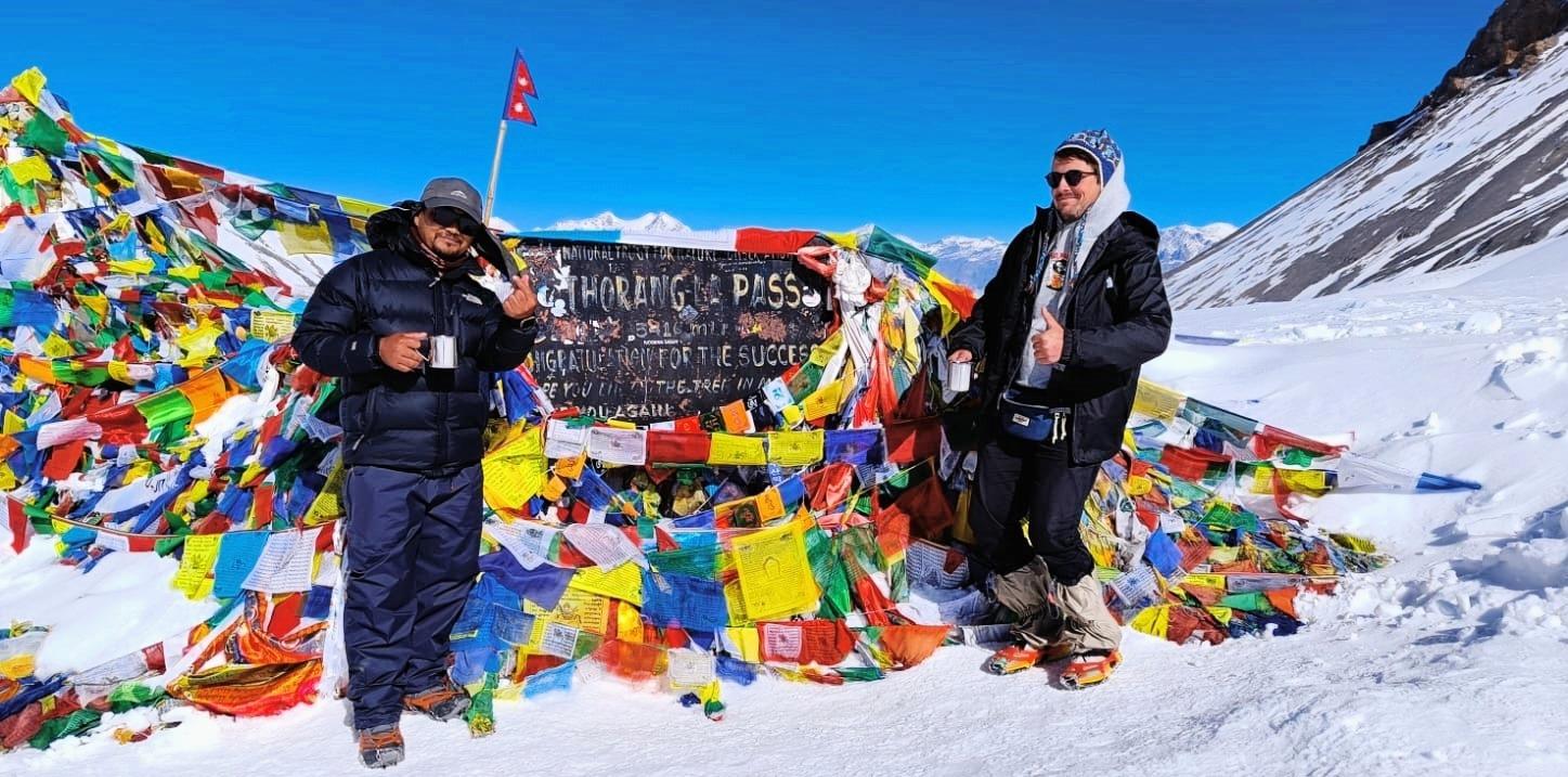
Trek To Bhimtang(3,720m) Via Larkya La Pass(5,106m).
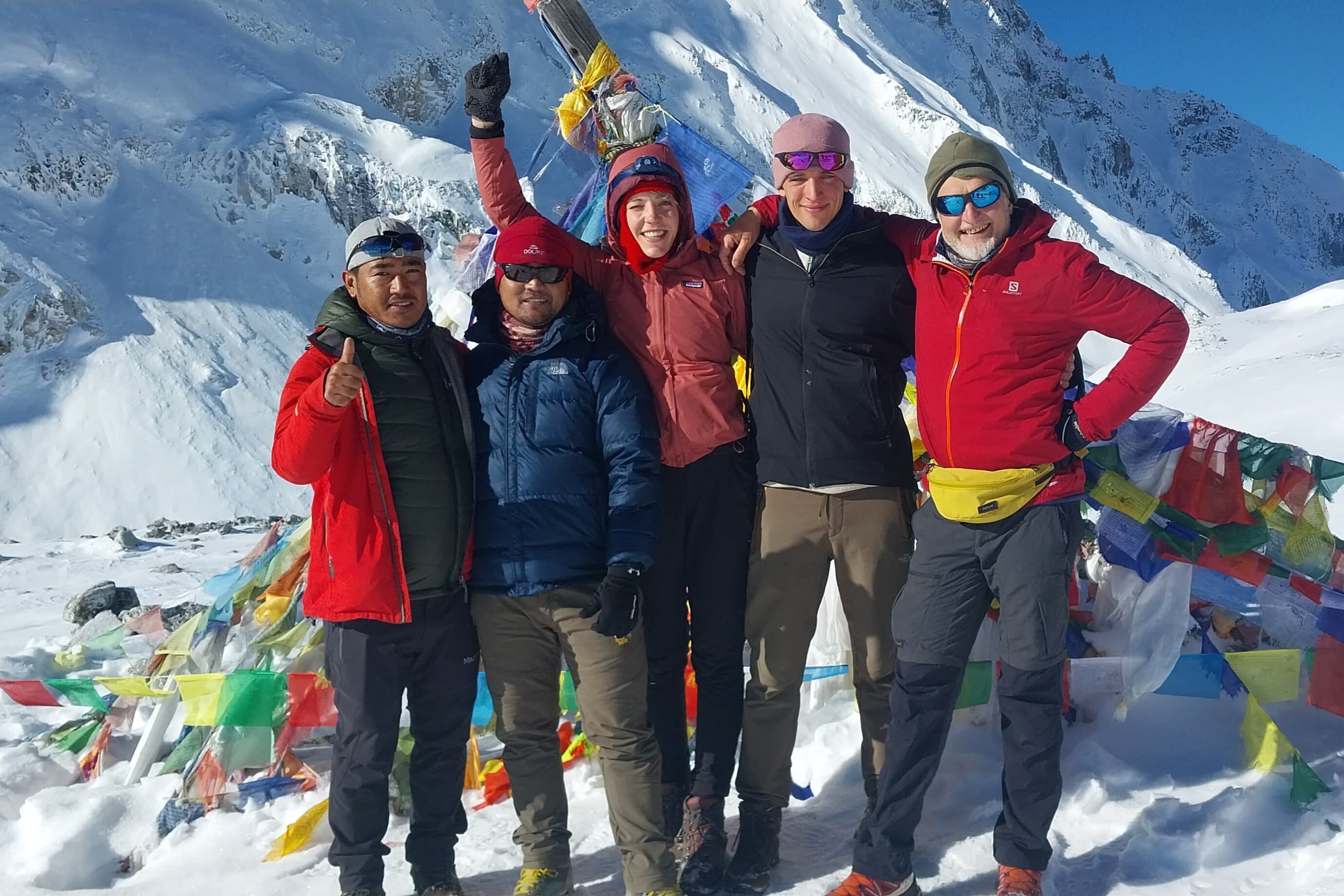
Trek Distance: 16 km. Trek Duration: 8-9 hrs. Elevation Gain/Loss: +700m at Larkya La Pass and -1,440m loss at Bhimtang. You wake long before dawn at Dharmashala , the icy wind howling through the moraine camp. The air is freezing, your breath visible as you gear up with warm layers, headlamp and walking sticks. This is the day you've been waiting for: the crossing of the Larkya La Pass(5,160m) , the highest point of your trek. You begin in darkness, your footsteps crunching on frozen ground. The trail climbs gradually at first, skirting glacial moraines and frozen steams. As the first light of dawn touches touches the snow peaks, the jagged silhouettes of Manaslu, Cheo Himal, Himlung Himal and Kang Guru glow golden against the deep blue sky. The climb is steady but relentless. You pass frozen lakes and rocky ridges, zigzagging upward. The air is thin, every breath heavy and you pace slows to a careful rhythm; step, breath, step, breath. Prayer flags flutter faintly in the distance, the signal that the pass is near. Finally, after about 3-4 hours of climbing, you stand at the Larkya La Pass(5,160m) . The moment is unforgettable. Prayer flags whip wildly in the wind , tied around a cairn marking the summit. From here, you're rewarded with a panoramic amphitheater of Himalayan giants . After the top, the descent begins cautiously. The trail is steep, winding down loose gravel, icy patches and snowfields. You tread carefully, as you descend, the barren high-altitude landscape gives way to greener alpine meadows , dotted with juniper and dwarf rhododendron. After a long and tiring descent, the valley opens wide, and you enter Bhimtang(3,720m), a breathtaking meadow surrounded by peaks. The village sits in a broad glacial basin, with jaw-dropping views of Mt. Manaslu(8,163m), Himlung Himal(7,126m), Cheo Himal(6,820m) and Lamjung Himal(6,983m) . Prayer flags flutter above the rooftops, yaks graze nearby and the exhaustion of the day melts away into sheer triumph. Overnight at a lodge in Bhimtang.
Day 14
Trek From Bhimtang To Tilche(2,300m) Or Dharapani(1,960m)
Trek Distance: 15-19 km. Trek Duration: 6-7 hrs. Elevation Loss: - 1,400m to - 1,700m. You wake in Bhimtang , a stunning glacial valley surrounded by the towering peaks of Manaslu, Himlung Himal, Cheo Himal and Lamjung Himal . The morning light paints the snowy summits gold and as you sip your tea, you take one last look at this high-altitude paradise .The trail begins with a gradual descent through wide yak pasture , where animals graze peacefully against the backdrop of glaciers. Soon, you cross a wooden bridg e over the dudh Khola(milk river) , its turquoise waters flowing down from the Larkya Glacier . The sound of the river follows you throughout much of today's trek. As you continue, the landscape changes quickly. The barren alpine world fades behind you , replaced by dense pine and rhododendron forests. In spring, the trail is alive with brilliant red and pink rhododendron blossoms , while in autumn, the leaves trun a warm golden brown . You breath more easily now as the altitude decreases and the air feels warmer and richer with each step. After about 3 hours, you reach Yak Kharka , a pastureland with herder huts , and then descend further into the thick forest. Waterfalls cascade from high cliffs and you cross several small wooden bridge s. The forest opens to the welcoming village of Gho(2,515m) , where trekkers often stop for rest or lunch . Stone houses, terraced fields and friendly locals greet you warmly. From Gho, the trail descends more gently. You pass through c ultivated farmland with terraced rice and millet fields spread across the hillsides. Mani walls, chortens and prayer flags remind you of the deep Buddhist culture that still thrives here. By late afternoon, you arrive at Tiche(2,300m) , a traditional Gurung settlemen t perched on the hillside. The stone-paved streets , prayer flags and warm smiles of villagers make you feel at home. After days of trekking through remote highlands, Tilche feels like a gateway back to the mid-hills, a place of transition where mountain and hill cultures meet. Overnight at a lodge in Tilche or Dharapani.
Day 15
Trek From Tilche To Dharapani Then Drive To Kathmandu(1,350m)
Trek Distance: 6 km. Trek Duration: 2 hrs. Drive Distance: 220 km Drive Duration: 8-9 hrs. Elevation Loss: -1050m. Your trek begins to Dharapani(1,860m) , after the last mountain breakfast in Tilche Village, a Gurung village tucked among terraced fields and prayer-flag-draped houses. From Tilche, you set out on you last trekking stretch. The trail descends steadily through lush forest, following the Dudh Khola River downstream . Birds sing in the trees, and the warmth of the lower altitude surrounds you. Stone-paved paths lead you through small hamlets, where children wave as you pass by. After about 2 hours of easy of walking , you arrive in Dharapani , a bustling crossroads village. Here, the Manaslu Circuit meets the Annapurna Circuit , so the atmosphere feels lively with trekkers from different routes crossing paths. Dharapani in lined with tea houses, stone houses and shops, a reminder that you're returning to busier trails, Where your jeep will be waiting for you . The road follows the Marsyangdi River , twisting through green valleys, deep gorges and terraced hillsides. You pass through villages like Tal, Chamje and Jagat , each perched above roaring rivers. The dirt track is bumpy in places, but the scenery-waterfalls tumbling down cliffs, suspension bridges swinging above rivers and hillsides dotted with rice terraces-keeps you captivated. Around the mid day you'll reach Besisaha r, the headquarter of Lamjung district , where the rough mountain road joins the paved highway to Kathmandu. You'll have a lunch here and keep continue driving to Kathmandu. Farewell dinner at 7pm in Kathmandu with cultural dances and souvenirs from Gurkha's Mountain Adventure. Overnight at a 4 star hotel in Kathmandu.
Day 16
Fly Back To Home Country
Transfer to airport by private vehicle; included, final goodbye, End of an epic Himalayan experience; unforgettable mountain memories. Thank You Very Much for being with us.
Day 1
Arrival In Kathmandu(1,350m)
Our team(trek guide/representatives) will be waiting for you at Tribhuvan International Airport in Kathmandu with garland of marigold flowers to have a warm welcome in the land of mountains. Transfer to hotel by a private car/vehicle then you will be briefing for preparation of the trek, shopping and rest time. Explore: Thamel's vibrant streets, traditional markets, visit Boudhanath/Swayambhunath if you arrived in time. Vibe: Buzzing cultural atmosphere, pre-trek excitement. Overnight at a 4 star hotel at Thamel in Kathmandu.
Day 2
Drive From Kathmandu To Barpak(1,900m)
Drive Distance: 150 km. Drive Duration: 8-9 hrs. Elevation Gain: +550m. Around 7:30am you'll leave your hotel and drive west along the Prithvi Highway , following the Trishuli River through green valleys, terraced hills and views of snow capped mountains . At Abukhaireni, you'll turn to the right, leaving the Pokhara highway behind. From here, the road climbs into the Gorkha region , winding past villages, forests and steep hillsides. The stretch is rough and narrow but every turn brings wider views. After about 8-9 hours of driving you'll reach at Barpak Village(1,900m) , Traditional Gurung and Ghale village with stunning views of Bauddha Himal(6,672m) . Reach the Earthquake-epicentr-2015 with resilient spirit. Overnight at a lodge in Barpak village.
Day 3
Trek From Barpak Village To Laprak Village(2,200m) Via Mamche Pass(2,910m)
Trek Distance: 9 km. Trek Duration: 5-6 hrs. Elevation Gain : +1010m at Mamche pass and +300m at Laprak village. You leave Barpak , the hillside Gurung and Ghale village famous for its resilience and stone-roofed houses , with the white summit of Boudha Himal(6,672m) gleaming above you. The trail reses gently at first through some terraced fields and slope hills, where local people greet you with a smile as they walking on the trail. As you climb higher, you step into cool forests of rhododendron and others. The air grows fresher and birdsong fills the silence. After a steady uphill push, you arrive at the broad ridge of Mamche Danda(2,850m) . Here, you pause to have a cup of hot drinks, where the world opens in all directions: to the north, the snow giants of Boudha Himal(6,672m), Himalchuli(7,893m), Sringi Himal(7,187m), Ganesh Himal range(Chamar-7,100m, Ganesh Nw-7,118m, Yangra-7,422m, Pabil-7,104m, Salasungo-7,043m) and Langtang Lirung(7,227m) rise in crystal clarity; to the south, rolling mid-hills stretch endlessly into the horizon. It feels as though you are standing on a natural balcony above the Himalayas. From Mamche after walking 20 minutes straight beside the weaving down through meadows, shepherd huts and whispering forests. the trail drops steeply and you'll pass the new Laprak village at Gupsipakha (settled after the Earthquake-2015) . Having a lunch at the new village, your trek will continue down to old Laprak village . You'll see Laprak spread out across a s loping hillside-a patchwork of stone houses, prayer flags and terraced fields glowing golden in the afternoon sun. By the time you step into the narrow stone lanes of Laprak(2,200m) , children run to greet you, and smoke rises from kitchen hearths. You feel as though you've entered a timeless Gurung settlement, where tradition and nature live in perfect balance.
Day 4
Trek From Laprak To Khorla Besi(970m)
Trek Distance: 16 km. Trek Duration: 6-7 hrs. Elevation Loss: -1,130m. Your trek begins leaving the traditional Gurung village of Laprak , walking through stone lanes and terraced fields that glow in the morning light. The trail first descend downwards to Jerbu river then after crossing a suspension bridge over the river the trail steadily begins to ascend till Singla village(Ganesh Himal Range will be very closed to you) and down to Khorla village and Khorlabesi . As you descend, the sound of the Budhi Gandaki River grows louder below, echoing through the gorge. You pass small settlements and fields of maize and millet, meeting villagers carrying baskets or leading mules along the trail. The path takes you down into subtropical forest , where you cross streams and walk beneath bamboo groves. You can feel the change in climate as the air grows warmer and more humid. The trail undulates-steep drops followed by short climbs- testing your knees and stamina . Finally, you reach the river and follow it downstream until you arrive at Khorlabesi(970m) , a lively riverside village. Here, the temperature feels warmer and you're back among banana trees, cardamom gardens and the chatter of locals. Overnight at a lodge at Khorla Besi by the side of Budhi Gandaki river.
Day 5
Trek From Khorla Besi To Jagat(1,340m)
Trek Distance: 13 km. Trek Duration: 5-6 hrs. Elevation Gain: + 370m. After having your breakfast the trek starts walking along the Budhi Gandaki River as the valley narrows into a gorge. The trail rises and falls, winding through forested hillsides and rocky paths. Before long, you reach Tatopani-990m(Natural hot spring) , bubble beside the trail. You may stop for a quick soak or simply enjoy the steam rising from the riverbank. From Tatopani, you will be walking along the road till beside Dobhan(1,070m) , From where you cross a suspension bridge to reach Dobhan-a small settlement where mule trains often pass, avoid the edge during their passing. The sound of their bells mixes with the rushing river as you continue along the trail. The path then leads through forest and cliffs, sometimes carved directly into rock , offering dramatic views of waterfalls tumbling into the gorge below. As you walk, you feel the atmosphere shift-the valley becomes wilder and more remote. The final stretch is a steady climb on stone staircases until you arrive at Jagat(1,340m) , a beautifully paved stone village perched on a ridge above the Budhi Gandaki. This is also the official entry checkpoint for the Manaslu Conservation Area(MCAP) , Where you register your permits. Overnight at a lodge in Jagat.
Day 6
Trek From Jagat To Deng(1,860m.)
Trek Distance: 19 km. Trek Duration: 6-7 hrs. Elevation Gain: +520m. You begin your morning walking out of Jagat, a stone-paved village with mani walls and a conservation checkpoint . The trail immediately offers a mix of stone staircases, suspension bridges and forested paths . The Budhi Gandaki River roars below as you move along cliffside trails . Soon, you pass through Sirdibas(1,430m ), a small Buddhist village with prayer flags and peaceful vib e. The mani walls and chortens here remind you that you are slowly entering Tibetan-influenced territory . Crossing a long suspension bridge , you ascend to Philim(1,570m) , a lager Gurung village . Here, neat houses, terraced fields and school supported by Japanese aid give the village a unique character. It's a perfect place to rest, sip tea and enjoy wide valley views. Beyond Philim, the valley opens into golden fields, then narrows again into a gorge with sheer cliffs . You walk under rocky overhang , where the river squeezes through dramatic stone walls . At Ekle Bhatti , you find a teahouse junction-one trail leads toward Tsum Valley , while your path continues along the Manaslu Circuit . The trail winds through forested slopes with tall pines and bamboo , where you may hear the calls of langurs or spot colorful Himalayan birds . You continue past Nyak and cross several small s treams on wooden planks or suspension bridges . Finally, after a long but gradual climb along the riverbank, you reach Deng(1,860m) , a small village with Tibetan-style houses . Smoke rises from the kitchens and you sense you are now deeper in Buddhist territory . Overnight at a teahouse in Deng.
Day 7
Trek From Deng To Namrung(2,630m)
Trek Distance: 18 km. Trek Duration: 6-7 hrs. Elevation Gain: +770m. Your trek begins in the early morning, crossing a suspension bridge over the Budhi Gandaki Rive r. The trail climbs steadily through dark pine and fir forests, where the sound of the river echoes below and sunlight filters through the trees. The air feels cooler now-you're climbing higher into the Himalayas. Soon, you pass Bihi Phedi(2,130m) , a small settlement where children may run out to greet you. From here, you catch glimpses of Kutang Himal(7,923m) rising sharply to the north, its white peak gleaming in the distance. Prayer flags and mani walls remind you that you are entering deeper into Tibetan Buddhist territory . The trail then meanders through forests and farmlands dotted with potatoes, barley, and buckwheat . You continue past several small hamlets, following the river and crossing wooden and suspension bridges . The gorge here feels narrower and steeper, with the Budhi Gandaki surging between high cliffs. As you climb further, you reach Ghap(2,160m ), a picturesque village with mani walls and colorful chortens. This is a good place for lunch break. Beyond Ghap, the trail enters enchanting forests of fir, rhododendron and bamboo , where you may hear the hooting of Himalayan pheasants or see troops of gray langur monkeys . You cross the river several times on suspension bridges , each crossing bringing new perspectives of the gorge and surrounding peaks . The path climbs steadily through forested slopes and farmland until you finally arrive at Namrung(2,630m) . Namrung feels different-it is a gateway village with a strong Tibetan Buddhist presence . Stone houses , prayer wheels , carved mani stones and the friendly smiles of villagers welcome you. Overnight at a lodge in Namrung.
Day 8
Trek From Namrung To Lho Gaon(3,180m)
Trek Distance: 11 km. Trek Duration: 4-5 hrs. Elevation Gain: +550m. After having your breakfast, you leave Namrung , a stone-built Buddhist village where prayer wheels line the pathways and the morning sun strikes the snow peaks above. From the village, the trail climbs gently through forests or fir, rhododendron and oak , opening occasionally to reveal terraces of barley, potatoes and wheat . As you walk, the valley widens and you are rewarded with stunning views of Ganesh Himal, Himal Chuli(7,893m) and Mount Manaslu(8,163m) ; the world 8th highest peak, towering above. The trail passes through small hamlets where children smile shyly, and farmers tend to their high-altitude crops . You reach Lihi Gaon(2,900m ), a beautiful village surrounded by chortens, barley fields and mani walls . The trail continues with short climbs and descents across steams and landslide sections until you arrive at Sho Gaon(2,950m) , another peaceful settlement. Here, the first full views of the giant Mountain; Manaslu's north face appear , a breathtaking sight that reminds you why this trek is so special. Finnally, you arrive at Lho Gaon(3,180m) , a spectacular village dominated by the majestic Ribung Gompa Monastery , which sits above the village like a guardian. From Lho , you enjoy sweeping views of Manaslu, Himal Chuli and Ngadi Chuli glowing golden at sunset. Overnight at a lodge in Lho Gaon.
Day 9
Trek From Lho Gaon To Sama Gaon)3,530m)
Trek Distance: 12 km. Trek Duration: 5-6 hrs. Elevation Gain: +350m. You trek starts early in the morning from Lho Gaon , a village dominated by the imposing Ribung Monastery and backed by the mighty Manaslu(8,163m) glowing in the morning sun. As you leave the village, you follow a forested trail where rhododendrons, pines and oaks give you refreshing shade. The walk feels gentle at first and you keep looking back for stunning views of Manaslu and Manaslu North standing tall behind you. Soon, you pass small chortens, mani walls and prayer flags fluttering in the wind-each reminding you that you're deep in the Nubri Valley , where Tibetan Buddhist culture is alive and thriving. The trail ascends gradually and after about an hour, you reach Shyala Village(3,500m) . Here, you're treated to a panoramic amphitheater of peaks : Himal Chuli(7,893m), Ngadi Chuli(7,871m), Manaslu and Ganesh Himal all surround you. You pause here, amazed at the sheer scale of the mountains. From Shyal, the trail becomes more open and you cross yak pastures where you might see herders tending their animals. You pass through alpine meadows filled with wildflowers in spring, while in autumn, the golden colors of the landscape take over. The air feels thinner, but the beauty of the surroundings keeps you energy high. Continuing on, you pass through the charming settlement of Pungen Gompa trail junction (a side trip option to Pungen Monastery , an ancient meditation site with a glorious view of the Manaslu glacier). If you don't take the side trip, you continue along the main trail toward Sama Gaon . The path now follows the valley floor beside the Budhi Gandaki River , its icy blue water rushing below you. The sound of the river accompanies your steps as you approach the broad and fertile valley of Sama Gaon . Before you arrive, you cross cultivated field s where locals grow barley and potatoes and you see children playing near stone houses with wooden roofs . Finally, you step into Sama Gaon(3,530m) , one of the most significant villages on the Manaslu Circuit . Here, you find yourself surrounded by a breathtaking mountain panorama, dominated by Manaslu's east face towering above the village. Sama Gaon is rich in Tibetan culture with mani walls, old monasteries and traditional stone houses welcoming you into this highland world. Overnight at a lodge in Sama Gaon.
Day 10
Acclimatization Day At Sama Gaon
Optional Hiking Distance: 10 km round trip from Sama Gaon to Pungen Gompa(4,000m). Optional Hiking Distance: 10-12 km round trip from Sama Gaon to Manaslu Base Camp(4,800m) Hiking Duration: 4-5 hr for Pungen Gompa and 6-7 hrs for Base Camp. Elevation Gain: +470m at Pungen Gompa and +1,270m at Base Camp. Two Options for hiking: Pungen Gompa(4,000m) - Starts south of Sama Gaon, gradually ascends through yak pastures, Scenic views of Manaslu, glaciers and beautiful glacial valley and reach Pungen Gompa with panoramic mountainous views. Ideal acclimatization hike; fewer crowds than the base camp route. Manaslu Base Camp(4,800m) - Steep uphill trail starting from Sama Gaon heading north toward the Base Camp of Manaslu, you will pass the forests of birch and rhododendron, glacier moraines and icy streams. More challenging but rewarding hike; spectacular close-up views of Mt. Manaslu, glaciers, and potential sightings of Himalayan wildlife. Overnight at the same lodge in Sama Gaon.
Day 11
Trek From Sama Gaon To Samdo(3,860m)
Trek Distance: 8 km. Trek Duration: 4-5 hrs. Elevation Gain: +330m. You begin your trek in the crisp morning air of Sama Gaon, surrounded by the towering Manaslu(8,163m) to the west. The village itself is a cultural gem , with mani walls, chortens and stone houses that make you feel as if time moves slower here. As you leave Sama, the trail gently ascends through alpine meadows dotted with grazing yaks . You follow the Budhi Gandaki River , its icy waters rushing alongside, carving a deep gorge into steps, rocky trails and open meadows , giving you a sense of variety with each turn. The valley narrows as you continue and the terrain becomes more rugged . You cross a few wooden bridge over icy steams and the higher altitude makes each step feel more purposeful. The yak herders' settlements you pass give you glimpses of high-altitude Himalayan life-men in traditional Tibetan dress, yaks grazing and stone houses with prayer flags fluttering in the wind. Finally, after a gradual climb through rocky terrain and past small herder shelters, you arrive at Samdo(3,860m) . The village sits like a jewel at the base of Manaslu's glacier, surrounded by dramatic peaks and barren slopes. Samdo marks the beginning of the high-altitude section of the Manaslu Circuit and you immediately feel the thin air, the silent grandeur and the raw beauty of the Himalayas. Overnight at a teahouse in Samdo Village.
Day 12
Trek From Samdo To Dharmashala(4,460m)
Trek Distance: 7 km. Trek Duration: 4-5 hrs. Elevation Gain: +600m. You wake up at Samdo , surrounded by the raw grandeur of the Himalayas . The morning light illuminates Manaslu's east face , glaciers sparkling in the sun . As you step onto the trail, the air feels crisp, thinner and every breath reminds you of the altitude. The trail ascends gradually along rocky slopes and moraine-strewn paths . You pass through yak pastures where herders guide their flocks and notice traditional Tibetan-style houses perched precariously on the slopes. Prayer flags flap in the wind, offering a spiritual blessing for your journey. As you climb higher, the vegetation disappears, replaced by barren alpine terrain, glacial rocks and ice-melt steams . The path winds steadily upward toward Dharmashala/Larkya Phedi , the high camp at the base of the Larkya La Pass(5,160m) . Along the way, you may see the way for Tibet border, trekkers resting, caravan of yaks and donkeys, flock of blue sheep, marmots and small chortens , symbols of human endurance in this extreme environment. Reaching Dharmashala(4,460m) in the early afternoon, you are greeted by panoramic views of Manaslu, Ngadi Chuli and Himal Chuli . The campsite sits on a wide moraine, providing space for tents and lodges. The wind is strong and the air thin, reminding you that this is high Himalayan territory and tomorrow's pass will be the most challenging and rewarding part of your trek. Overnight at a teahouse in Dharmashala.
Day 13
Trek To Bhimtang(3,720m) Via Larkya La Pass(5,106m).
Trek Distance: 16 km. Trek Duration: 8-9 hrs. Elevation Gain/Loss: +700m at Larkya La Pass and -1,440m loss at Bhimtang. You wake long before dawn at Dharmashala , the icy wind howling through the moraine camp. The air is freezing, your breath visible as you gear up with warm layers, headlamp and walking sticks. This is the day you've been waiting for: the crossing of the Larkya La Pass(5,160m) , the highest point of your trek. You begin in darkness, your footsteps crunching on frozen ground. The trail climbs gradually at first, skirting glacial moraines and frozen steams. As the first light of dawn touches touches the snow peaks, the jagged silhouettes of Manaslu, Cheo Himal, Himlung Himal and Kang Guru glow golden against the deep blue sky. The climb is steady but relentless. You pass frozen lakes and rocky ridges, zigzagging upward. The air is thin, every breath heavy and you pace slows to a careful rhythm; step, breath, step, breath. Prayer flags flutter faintly in the distance, the signal that the pass is near. Finally, after about 3-4 hours of climbing, you stand at the Larkya La Pass(5,160m) . The moment is unforgettable. Prayer flags whip wildly in the wind , tied around a cairn marking the summit. From here, you're rewarded with a panoramic amphitheater of Himalayan giants . After the top, the descent begins cautiously. The trail is steep, winding down loose gravel, icy patches and snowfields. You tread carefully, as you descend, the barren high-altitude landscape gives way to greener alpine meadows , dotted with juniper and dwarf rhododendron. After a long and tiring descent, the valley opens wide, and you enter Bhimtang(3,720m), a breathtaking meadow surrounded by peaks. The village sits in a broad glacial basin, with jaw-dropping views of Mt. Manaslu(8,163m), Himlung Himal(7,126m), Cheo Himal(6,820m) and Lamjung Himal(6,983m) . Prayer flags flutter above the rooftops, yaks graze nearby and the exhaustion of the day melts away into sheer triumph. Overnight at a lodge in Bhimtang.
Day 14
Trek From Bhimtang To Tilche(2,300m) Or Dharapani(1,960m)
Trek Distance: 15-19 km. Trek Duration: 6-7 hrs. Elevation Loss: - 1,400m to - 1,700m. You wake in Bhimtang , a stunning glacial valley surrounded by the towering peaks of Manaslu, Himlung Himal, Cheo Himal and Lamjung Himal . The morning light paints the snowy summits gold and as you sip your tea, you take one last look at this high-altitude paradise .The trail begins with a gradual descent through wide yak pasture , where animals graze peacefully against the backdrop of glaciers. Soon, you cross a wooden bridg e over the dudh Khola(milk river) , its turquoise waters flowing down from the Larkya Glacier . The sound of the river follows you throughout much of today's trek. As you continue, the landscape changes quickly. The barren alpine world fades behind you , replaced by dense pine and rhododendron forests. In spring, the trail is alive with brilliant red and pink rhododendron blossoms , while in autumn, the leaves trun a warm golden brown . You breath more easily now as the altitude decreases and the air feels warmer and richer with each step. After about 3 hours, you reach Yak Kharka , a pastureland with herder huts , and then descend further into the thick forest. Waterfalls cascade from high cliffs and you cross several small wooden bridge s. The forest opens to the welcoming village of Gho(2,515m) , where trekkers often stop for rest or lunch . Stone houses, terraced fields and friendly locals greet you warmly. From Gho, the trail descends more gently. You pass through c ultivated farmland with terraced rice and millet fields spread across the hillsides. Mani walls, chortens and prayer flags remind you of the deep Buddhist culture that still thrives here. By late afternoon, you arrive at Tiche(2,300m) , a traditional Gurung settlemen t perched on the hillside. The stone-paved streets , prayer flags and warm smiles of villagers make you feel at home. After days of trekking through remote highlands, Tilche feels like a gateway back to the mid-hills, a place of transition where mountain and hill cultures meet. Overnight at a lodge in Tilche or Dharapani.
Day 15
Trek From Tilche To Dharapani Then Drive To Kathmandu(1,350m)
Trek Distance: 6 km. Trek Duration: 2 hrs. Drive Distance: 220 km Drive Duration: 8-9 hrs. Elevation Loss: -1050m. Your trek begins to Dharapani(1,860m) , after the last mountain breakfast in Tilche Village, a Gurung village tucked among terraced fields and prayer-flag-draped houses. From Tilche, you set out on you last trekking stretch. The trail descends steadily through lush forest, following the Dudh Khola River downstream . Birds sing in the trees, and the warmth of the lower altitude surrounds you. Stone-paved paths lead you through small hamlets, where children wave as you pass by. After about 2 hours of easy of walking , you arrive in Dharapani , a bustling crossroads village. Here, the Manaslu Circuit meets the Annapurna Circuit , so the atmosphere feels lively with trekkers from different routes crossing paths. Dharapani in lined with tea houses, stone houses and shops, a reminder that you're returning to busier trails, Where your jeep will be waiting for you . The road follows the Marsyangdi River , twisting through green valleys, deep gorges and terraced hillsides. You pass through villages like Tal, Chamje and Jagat , each perched above roaring rivers. The dirt track is bumpy in places, but the scenery-waterfalls tumbling down cliffs, suspension bridges swinging above rivers and hillsides dotted with rice terraces-keeps you captivated. Around the mid day you'll reach Besisaha r, the headquarter of Lamjung district , where the rough mountain road joins the paved highway to Kathmandu. You'll have a lunch here and keep continue driving to Kathmandu. Farewell dinner at 7pm in Kathmandu with cultural dances and souvenirs from Gurkha's Mountain Adventure. Overnight at a 4 star hotel in Kathmandu.
Day 16
Fly Back To Home Country
Transfer to airport by private vehicle; included, final goodbye, End of an epic Himalayan experience; unforgettable mountain memories. Thank You Very Much for being with us.


Uncover Hidden Wilderness Together!
Often celebrated as a harmonious union of physical activity and natural exploration become an enriching journey for both body and mind.
